Hanoi should learn the lessons of the past in terms of urban planning

Mr. Tran Trong Hanh, former rector of Hanoi University of Architecture and former member of the People’s Council of Hanoi, said that the inadequate management process for decades has not helped to take into account the advantage of rivers close to the city, especially in the case of Hanoi. Red River.

Construction works along both sides of the river did not develop together. Due to a lack of planning, all architectural works and houses on both sides of the Red River face backwards onto the river.

Mr. Duong Duc Tuan, vice president of Hanoi, said the new development master plan aims to make the Red River the main axis of the capital, connecting with the West Lake-Co Loa axis to form the center of the central urban area. from Hanoi.

In this area, a system of parks, iconic works of the capital and historical spaces, conservation areas, landscapes and tourist spots such as West Lake, Co Loa and Bat Trang will be developed.

As the developer of the Red River Urban Zoning Master Plan, the Hanoi Construction Planning Institute said that with the new planning, “Hanoi will face the Red River for development.”

According to the Vietnam Urban Development Planning Association, when Hanoi expands its boundaries, it will be necessary to save space for the Red River by not building many skyscrapers on its sides.

The most important feature is to build two roads along both sides of the Red River on the north and south banks. With these two roads, there will be no encroachment on the banks.

With the formation of two roads along the Red River, many houses will have to be removed. Once the riparian route is formed, the construction of high-rise buildings and houses should be prohibited.

In 2008, the National Assembly issued a resolution to expand the administrative boundaries of the capital. As a result, Hanoi’s area grew to 3,324 km2. For such a large area, the Red River space must be preserved.

Bao Van

UP42 and Airbus launch the Copernicus Masters Challenge for Sustainable Urban Planning

Calling all developers and researchers to leverage remote sensing to accelerate the United Nations Sustainable Development Goals

BERLIN, May 18, 2022 – UP42, a leading geospatial development platform and marketplace, and its parent company Airbus are teaming up for the Copernicus Masters Challenge. Their sustainable urban planning challenge focuses on remote sensing for better decision making.

The world’s most prestigious annual Earth Observation (EO) competition, Copernicus Masters aims to foster innovative applications of remote sensing data that address Earth’s pressing environmental, social and business issues.

The European Commission and other international public entities have implemented several urban development projects to address critical issues related to sprawl, such as unemployment, segregation and poverty. UP42 and Airbus are now calling on developers and researchers from around the world to create algorithms and analyzes capable of providing decision-makers with better quantitative information, with a particular focus on ecology.

“We are on a mission to democratize Earth observation data and information,” said Sean Wiid, CEO of UP42. “We want to give urban planning experts and decision makers easier access to data to develop and scale solutions faster, removing technical and market barriers that can slow progress in making cities and communities greener and more livable by 2030.”

In the same spirit of sustainability, last year’s winners, Thetaspace, has developed CloudlessEO – an algorithm that uses Deep Learning technology to remove clouds in optical satellite imagery and help solve environmental problems in tropical areas. The German company was recently awarded with the Global Geospatial Innovation Award 2022 in SAR-Optical Data Fusion with their CloudlessEO solution.

Qualitative and quantitative information

With a growing need for data points and quantitative analysis To help planners effectively make cities more sustainable by considering a city’s entire ecosystem, remote sensing is an essential tool for performing in-depth large-scale analysis. However, recent studies show that the the level of integration between remote sensing, urban planning and ecology is still limited“with only 12% of papers fully integrating ecology, remote sensing and planning, while 24% of studies use single domain specific methods.”

Developers who take up the Airbus UP42 Challenge have a significant opportunity to design solutions that will have a tangible impact on the race for sustainability by 2030.

“We are delighted to participate again in this new edition of the Copernicus Masters. Sustainable urban planning is essential to face the evolutions of climate change, and we look forward to finding creative partners to develop innovative solutions that will have a positive impact on the environment and society through this new challenge,” said Matthieu Lys, head of innovation management. , Airbus Defense and Space.

Evaluation and price

The UP42 Airbus Copernicus Masters Challenge on Sustainable Urban Planning aims to develop algorithms or methodologies that use remote sensing to quantify critical issues emerging from the expansion from historic centers to modern suburbs.

Participants are encouraged to tackle use cases that leverage UP42’s most diverse data, including but not limited to the following:

  • The proliferation of works having an impact on non-renewable resources (water, vegetation, soil)
  • The uneven distribution of green sites
  • Lost spaces to be converted into green or residential areas

During the submission phase, all participants will have access to advanced geospatial data, cloud infrastructure, and ready-to-use algorithms through the UP42 platform.

The winners are entitled to 80,000 euros in OneAtlas credits to access Airbus commercial satellite data and 20,000 euros in UP42 credits to access all types of geospatial data and algorithms on the market.

Additionally, winners can become official partners of UP42 and have their solutions included in a global AI-powered ecosystem of 55+ vendors, 170+ data and algorithms, and approximately 35,000 registrations on the platform. Either way, UP42 will provide winners with ongoing customer support to further develop EO solutions.

Ideas and solutions can be submitted until July 11, 2022. Please visit the UP42 Airbus Copernicus Masters Challenge webpage for more information: https://copernicus-masters.com/challenges/up42-challenge/

Please watch the video: https://youtu.be/ynw4iGMjTyo

About UP42
UP42 changes the way geospatial data is viewed and analyzed. The platform and marketplace brings together multiple data sources such as satellite imagery, weather data, etc., along with algorithms to identify objects, detect changes, and find patterns. Industry leaders use UP42 to inform business decisions and create scalable customer solutions. Know when and where to fertilize crops. Measure air quality and map emissions. Count cars, trucks, planes and ships. Developers and data scientists from all industries now have access to a platform to build, run, and scale projects in one place. To visit www.up42.com.

About Airbus

Airbus is the pioneer of sustainable aerospace for a safe and united world. The Company is constantly innovating to provide efficient and technologically advanced solutions in the fields of aerospace, defense and connected services. In commercial aircraft, Airbus offers modern, fuel-efficient airliners and related services. Airbus is also a European leader in defense and security and one of the world leaders in space. In helicopters, Airbus provides the world’s most successful civil and military rotorcraft solutions and services. To visit www.airbus.com/en/products-services/space

Related articles on GISuser:

Stakeholders identify urban planning as a serious health problem

Synagogue Church of All Nations, Accra

A two-day stakeholder planning workshop, aimed at developing a strategic plan to improve health conditions in urban settlements, has concluded in Ashaiman in the Greater Accra region.

Stakeholders would also design a slum upgrading plan that would indicate how sustainable urban development can be achieved for the maintenance of good health in these communities.

Stakeholders in research efforts would create new methodological and translational innovations that integrate and go beyond discipline-specific approaches to solving a common problem in urban communities faced with the provision of essential amenities.

It brought together experts and practitioners in the field of sustainable urban development and health, working closely with local communities, city officials and development partners within the framework of “Developing Resilient African Cities and their urban environments”.

It was organized by DREAMS, a transdisciplinary research project, made up of researchers from different disciplines, in partnership with the University of Ghana and funded by Belmont Forum, an international partnership that mobilizes funds for environmental change to remove barriers criticisms of sustainability.

Dr. Maame Gyeke-Jandoh, Head of Department of Political Science and School of Social Sciences, University of Ghana, who was the Ghana Dreams Team Leader, in an interview with Ghana News Agency , expressed concern about the health problems of the slums. communities in Africa, and urged participants to identify key initiatives and action items to guide their slum environment design efforts in the context of knowledge co-development.

She said that through the workshop, participants would understand the challenges the communities were facing, adding that “we will work together to overcome them” and strategically plan slum development to reduce the impact by identifying the best approaches to address. challenges.

Dr Gyeke-Jandoh said: “There is a limit from authorities but the biggest challenges were with the people themselves and how they perceived health issues in localities.”

Mr. Francis Hans-Jorie, President of City 2000 Youth Action International (C2YA), non-governmental organization and local partners of the DREAM project, and member of the Economic, Social and Cultural Council (ECOSOCC) who welcomed the participants declared: “We are witnessing urbanization and the creation of slums in most of our cities” and urged participants to intensify their research efforts to ensure a healthy and quality environment.

“That is why it has become important to bring stakeholders together to deliberate on best practices for slum upgrading to improve people’s livelihoods and health conditions,” he said.

Prof Christine Furst, head of DREAM Project International, presenting an overview of the programme, said people go to cities because they want to have a better economic situation.

“We need to know why they migrate and for them to understand it better. This is a great opportunity to see how Africa and cities can work together to ensure good basic amenities,” she said.

Professor Henry Bulley, a member of the DREAM project who also spoke about the Charrette, a workshop dedicated to a concerted effort to solve a problem or plan the design of something, urged participants to engage community members to come up with a lasting solution to the problems. .

“The solution of informal settlement would never be achieved unless we connect it to what is happening in communities and find best practices to address these issues,” he said.

Send your news to [email protected] and via WhatsApp to +233 244244807
Follow Ghana News on Google New

UP42 and the Airbus Copernicus Masters Challenge for sustainable urban planning – SatNews

This prestigious annual Earth Observation (EO) competition, Copernicus Masters, aims to develop innovative applications of remote sensing data that address the Earth’s current environmental, social and business challenges.

UP42, a platform and marketplace for geospatial developers, and its parent company Airbus are teaming up for the Copernicus Masters Challenge. Their sustainable urban planning challenge focuses on remote sensing for better decision making.

This prestigious annual Earth Observation (EO) competition, Copernicus Masters, aims to develop innovative applications of remote sensing data that address the Earth’s current environmental, social and business challenges.

The European Commission and other international public entities have implemented several urban development projects that will tackle issues related to sprawl, such as unemployment, segregation and poverty. UP42 and Airbus are now encouraging developers and researchers around the world to create algorithms and analytics that can provide decision makers with better quantitative information, and a particular focus on ecology.

“We are on a mission to democratize Earth observation data and information,” mentioned Sean Wiid, CEO of UP42. “We want to give urban planning experts and decision makers easier access to data to develop and scale solutions faster, removing technical and market barriers that can slow progress in making cities and communities greener and more livable by 2030.”

In the same topic of sustainability, last year’s winners, Thetaspace, has developed CloudlessEO – an algorithm that uses Deep Learning technology to remove clouds in optical satellite imagery and help solve environmental problems in tropical areas. The German company was recently awarded with the Global Geospatial Innovation Award 2022 in SAR-Optical Data Fusion with their CloudlessEO solution.

Qualitative and quantitative information

With a growing need for data points and quantitative analysis To help city planners make cities more sustainable by considering a city’s entire ecosystem, remote sensing is an essential tool for performing in-depth large-scale analysis. However, recent studies show that the the level of integration between remote sensing, urban planning and ecology is still limitedwith only 12% of papers fully integrating ecology, remote sensing and planning while 24% of studies use single domain specific methods.

Developers participating in the UP42 Airbus Challenge have a significant opportunity to design solutions that will have a tangible impact on the race for sustainability by 2030.

We are delighted to participate again in this new edition of the Copernicus Masters. Sustainable urban planning is essential to face the evolutions of climate change, and we look forward to finding creative partners to develop innovative solutions that will have a positive impact on the environment and society through this new challenge”, mentioned Matthieu Lys, Head of Innovation Management, Airbus Defense and Space.

Evaluation and price

The UP42 Airbus Copernicus Masters Challenge on Sustainable Urban Planning aims to develop algorithms or methodologies that use remote sensing to quantify critical issues emerging from the expansion from historic centers to modern suburbs.

Entrants are encouraged to use cases that leverage the most diverse data from UP42, including, but not limited to, the following:

  • The proliferation of works having an impact on non-renewable resources (water, vegetation, soil)
  • The uneven distribution of green sites
  • Lost spaces to be converted into green or residential areas

During the submission phase, all participants will have access to advanced geospatial data, cloud infrastructure, and ready-to-use algorithms through the UP42 platform.

The winners are entitled to 80,000 euros in OneAtlas credits to access Airbus commercial satellite data and 20,000 euros in UP42 credits to access all types of geospatial data and algorithms on the market.

Additionally, winners can become official partners of UP42 and have their solutions included in a global AI-powered ecosystem of 55+ vendors, 170+ data and algorithms, and approximately 35,000 platform registrations. Either way, UP42 will provide winners with ongoing customer support to further develop EO solutions.

Ideas and solutions can be received until July 11, 2022. Please visit the UP42 Airbus Copernicus Masters Challenge webpage for more information: https://copernicus-masters.com/challenges/up42-challenge/

Please watch the video: https://youtu.be/ynw4iGMjTyo

UTS’s online Master in Urban Planning prepares forward-looking planners who want to make an impact on society

Well over half of the world’s population will call a city home by 2050[1]but whether these cities are both livable and resilient will largely depend on the technical and creative skills brought to the challenge by today’s emerging experts in urban planning and urban design.

For cities and towns to continue to grow, many of the key decisions needed to successfully respond to change are happening right now, showing the demand for more skilled professionals in this field.

The online Master in Urbanism is aimed at candidates from a non-urban planning field, the multidisciplinary learning allowing professionals to change careers. It is also ideal for professionals who want to strengthen their current skills by engaging in up-to-date and groundbreaking planning approaches.

Professor Heather MacDonald, a planning scholar and associate dean of UTS’s Faculty of Design, Architecture and Construction, believes that the ability to negotiate solutions among many competing stakeholders (neighbours, environmental advocates environment, real estate developers and local businesses) and to invent new solutions to complex conflicts is one of the main skills that planners need.

“Planners need to be able to gather and analyze different kinds of evidence to weigh the outcomes of alternative decisions and support better-informed public debate,” she said.

UTS Online helps students find practical approaches to urban planning in many different fields. Students in the university’s online course also learn to apply their analytical skills to determine constraints and opportunities, thereby improving their ability to plan strategically. ??

Many industries are adopting sustainable practices. This is why universities like UTS, one of Australia’s leading online institutions, are seeing their Masters in Urban Planning Online Course as the best way to prepare professionals for the future. Students learn to apply sustainable planning practices to various projects. The course also encourages original thinking to find solutions to unconventional problems.

While many other universities offer postgraduate degrees in planning, UTS’s approach to the subject is what sets it apart. UTS online Master in Urbanism is designed for professionals who want to actively develop their skills and knowledge to become effective planners and create sustainable urban environments. Students learn to navigate real-life opportunities while understanding the importance of cultural, economic, and political contexts when planning for communities.

The course is delivered 100% online and explores various aspects of urban development – ​​including social sustainability, the environment and legislation – to help achieve the best possible outcome.

“We have students from many professional backgrounds studying the Master in Urban Planning – from teachers to project managers and field officers. Either way, the goal of the course is to ensure that our students actually master what is needed to become effective planners,” said a UTS Online representative.

“The course comprises 15 subjects and can be completed in as little as two and a half years. Most of our students are working professionals, some with families and full-time jobs, so we encourage them to study at their own pace. After all, the goal is to ensure that our students are knowledgeable about the subject,” the representative added.


Learn more about the UTS Online Master of Urban Planning here:
https://studyonline.uts.edu.au/online-courses/master-urban-planning

1- https://population.un.org/wup/Publications/Files/WUP2018-PressRelease.pdf

About UTS Online:

UTS is currently ranked among the best young universities in Australia. He is ranked number 11 in the world. Its courses are designed to ensure that students receive the best education possible. The online Master in Urban Planning and other courses are all delivered through an interactive and innovative platform for students to learn at their own pace. However, all students receive the necessary support to ensure that they develop the required skills by the end of the course.

Contact information:
Name: UTS Online
E-mail: Send an email
Organization: UTS online
Address: Sydney, NSW, Australia
Telephone: 1300 477 423
Website: https://studyonline.uts.edu.au/online-courses/master-urban-planning

Build ID: 89075912

If you detect any problems, problems or errors in the content of this press release, please contact [email protected] to let us know. We will respond and rectify the situation within the next 8 hours.

countex tracking

COMTEX_407961694/2773/2022-05-30T13:22:35

UP42 announces the Copernicus Masters Challenge for Sustainable Urban Planning

The European Commission and other international public entities have implemented several urban development projects to address critical issues related to sprawl, such as unemployment, segregation and poverty. UP42 and Airbus are now calling on developers and researchers from around the world to create algorithms and analyzes capable of providing decision-makers with better quantitative information, with a particular focus on ecology.

“We are on a mission to democratize Earth observation data and information,” Wiid said. “We want to give urban planning experts and decision makers easier access to data to develop and scale solutions faster, removing the technical and business barriers that can slow progress in making cities and communities healthier. green and more livable by 2030,” he added.

In recent years, the Copernicus program – the European Union’s own EO program – has grown by leaps and bounds. The information services provided by the program are free and freely accessible. “The economic value that has been generated on top of this data by companies building solutions or providing consulting services is enormous,” Wiid said. geospatial world in August 2021. Not only has it proven to be a boon for commercial and private users, but it has also benefited the scientific community, policy makers and researchers.

Remote sensing is an essential tool for performing in-depth large-scale analysis to effectively make cities more sustainable by considering the entire ecosystem of a city. Nevertheless, Literature shows that the level of integration between remote sensing, town planning and ecology can still be improved.

Long-standing planning issues behind Hanoi floods

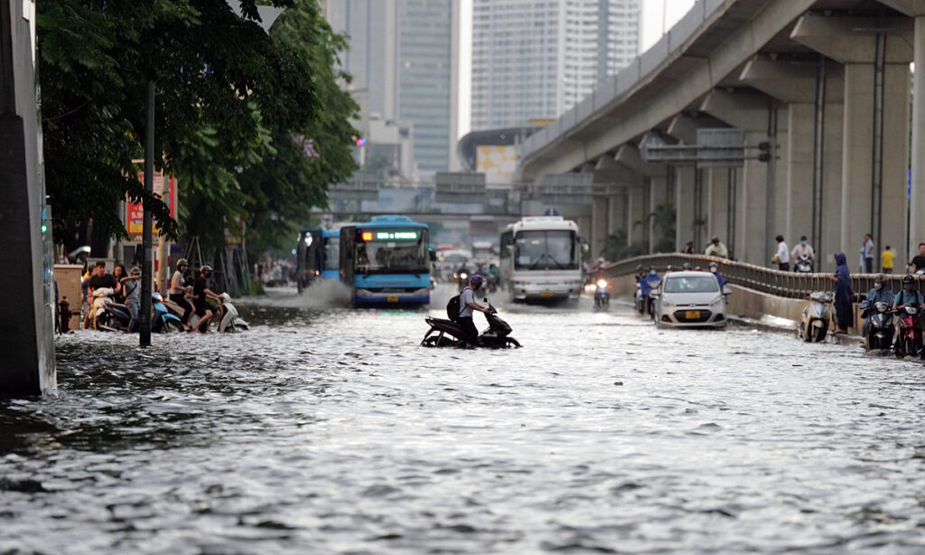
On Sunday and Monday, more than 80 places were flooded following the incessant rains, paralyzing traffic throughout the city. As rising waters invaded homes and upended lives, authorities and policy makers racked their brains trying to figure out why Hanoi is so vulnerable to flooding when it rains.

Historical rain levels

Over two hours into the afternoon last Sunday, weather stations on Lang Street in Dong Da district recorded 138mm of rain, 6mm more than the previous record of 132.5mm in 1986, according to the National Center for Hydrometeorological Prediction.

There were places with even higher rainfall like Tay Ho district (150mm) and Cau Giay district (170mm).

The 170mm of rain recorded in two hours in Cau Giay is considered the highest ever recorded in Hanoi, the center said, adding that such rains only occur once every 100 years.

Trinh Ngoc Son, deputy director of the Hanoi Drainage Company, said historic levels of rainfall were overloading the city’s drainage capacity.

Some places to the west like the Keangnam Building and Phan Van Truong Street did not see the water recede until after 10 p.m.

“Even developed countries don’t have the financial capacity to design a drainage system that can handle such a large amount of water,” Son said.

Natural Resources and Environment Minister Tran Hong Ha said global warming is triggering extreme weather events.

“If heavy rains are concentrated in a short period of time, no infrastructure can cope with it.”

Unsynchronized drainage systems

Hanoi has 29 districts and one city, with 12 inner districts spanning 250 km2.

The To Lich River watershed, which covers 77.5 km2, covers all districts of Ba Dinh, Hoan Kiem, Dong Da, Hai Ba Trung and Hoang Mai, and part of Tay Ho and Thanh districts. Xuan.

It can drain 310mm of rain in two days, but heavy downpours can cause flooding.

The 110 km² watershed of the Nhue River extends over the districts of Cau Giay, Thanh Xuan, Hoang Mai, Nam Tu Liem, Bac Tu Liem and Ha Dong and parts of Tay Ho and Thanh Tri. It has a high rate of urbanization but a modest drainage capacity, lacks reservoirs and its main pumps have not yet reached their planned capacity.

In the Long Bien River Basin, rainwater flows naturally by flowing into the Nam Stream, Tam Dau Canal and Cau Bay River, and the Dong Tru Pumping Station directs it into the Duong River. .

In the rest of the city, sewers carry water to surrounding fields and lakes. Thanks to a large number of lakes and ponds, flooding is rare in these areas.

Nguyen The Cong, deputy director of the city’s construction department, said the drainage system is synchronized only in inner districts.

The districts of Ha Dong, Long Bien, Bac Tu Liem and Nam Tu Liem have yet to see any investment in drainage construction, however, meaning they can be flooded if there is enough rain.

Cong said the capital is planning to synchronize its pumping and drainage systems, but this requires a lot of money and could therefore take five or 10 years.

Investment, planning issues

Vu Trong Hong, the former Minister of Agriculture and Rural Development, said that in several city centers, drainage systems have existed since the French colonial era, which means they are outdated and cannot meet today’s urban needs.

Due to lack of funds to improve the drainage system, the same places in city centers continue to be flooded year after year, he said.

There are now new flood points in outlying districts like Cau Giay, Ha Dong, Bac Tu Liem and Nam Tu Liem, all of which are developing areas with rapid population growth and urbanization rates, said Hong.

Pham Thanh Tung, bureau chief of the Vietnam Association of Architects, said Hanoi has invested in its water drainage system over the past two years, but the results are unclear.

The city has limited resources but too many projects, and the construction of pumping stations and drainage systems simply could not keep up with its rate of urbanization, and this combined with the effects of climate change is leading to flooding, he said. -he declares.

Hoang Van Cuong, deputy director of the National University of Economics, said one of the reasons for flooding in Hanoi is overlapping planning by various agencies.

Houses and other urban structures are being built without considering the water drainage systems that are needed, he explained.

“According to the 2017 planning law, the construction of infrastructure, irrigation and agricultural works must be synchronized.

“If we do this right, big cities like Hanoi could solve their flooding problems.”

Nguyen Van Lien, the former deputy construction minister, also said urban development without paying attention to water supply and drainage is the reason floods occur year after year.

Disappearance of lakes, trees

Lien also expressed concern about the relentless decline in water bodies and green cover in Hanoi.

As more and more concrete is used, water finds it difficult to seep into the ground and naturally flows to lower areas, creating flooding, he said.

“Hanoi is lower in the middle, and it’s still the most flooded area.”

The capital has yet to announce official statistics for encroachment on ponds and lakes, but a report by the Center for Environment and Community Research says 17 downtown lakes have completely disappeared while only seven new ones were created. The total water surface thus fell from 2,100 ha before 2010 to only 1,165 ha in 2015.

Lien said one solution is to expand lakes, ponds and grass fields in downtown Hanoi so there is enough space for water to drain.

The city must also complete its drainage and pumping station works and synchronize the drainage network in new districts.

Tung said Hanoi could learn from anti-flooding strategies adopted by cities around the world, such as building reservoirs underground.

Upcoming Trends of Urban Planning and Design Software Market Segmented by Type, Application, End-User, and Region -SketchUp, City Form Lab, ESRI, Holistic City, Lumion, Bentley, UrbanSim, Modelur, UrbanFootprint, SimWalk, Urban ROI Designate

The Global Urban planning and design software Market: 2022 was recently released by the Mr Accuracy Reports. The report offers a tip on the Urban Planning and Design Software Marketwhich helps business strategists make the best investment assessment.

The Urban Planning and Design Software Market industry report includes details of the historical analysis of the Urban Planning and Design Software Market, which has a timeline from 2017 to 2020. The current state of the market urban planning and design software is also well discussed in the report along with the forecast analysis of the market till 2030. The report starts with the basic overview of the urban planning and design software market which includes the market definition, market scope and target audience. In the last section, market dynamics are thoroughly defined which includes market drivers, restraints, opportunities, challenges, market advancements in terms of technology and others.

Some of the Major Key Players profiled in the study are SketchUp, City Form Lab, ESRI, Holistic City, Lumion, Bentley, UrbanSim, Modelur, UrbanFootprint, SimWalk, Urban ROI Designer

Get a free sample report + all related charts and graphs (with COVID 19 impact analysis): https://www.maccuracyreports.com/report-sample/192676

Asia-Pacific is expected to dominate the market over the forecast period owing to the growing focus on the research, development, and manufacturing of urban planning and design software in countries such as China, Japan, India and South Korea.

Report objectives:

  • To study the Urban Planning and Design Software Market size based on value and volume.
  • To accurately assess market shares and other important factors of the Urban Planning and Design Software Market.
  • To analyze the key dynamics of Urban Planning and Design Software Market.
  • Discover significant Urban Planning and Design Software Market trends based on revenue, production, and sales.
  • Define the profile of the best players and their status on the global platform
  • Focus on market pricing, product manufacturing, growth drivers and forecast trends.
  • To study the performance and growth of different regions and countries in the Urban Planning and Design Software Market.
  • Estimating the size and market share of all segments, regions and the market.

In addition, the report includes types of urban planning and design software market segments. The product type and application segments are explained in detail with the help of yearly number and growth rate. The data is represented in the form of tables and images thus allowing a clear understanding of the market scenario. The regional analysis includes data for regions such as North America, Europe, Asia-Pacific, Latin America, Middle East and Africa.

Urban Planning and Design Software Market Taxonomy

Urban Planning and Design Software Segmentation by Type:

Cloud-based, web-based.

Urban Planning and Design Software Segmentation by Application:

Architects, urban planners, creative services

We are currently offering an end of quarter discount to all of our high potential clients and would really like you to take advantage of the benefits and leverage your analysis based on our report.

Market analysis and insights related to COVID-19

  • Due to the outbreak of the COVID-19 virus in December 2020, the pandemic has affected almost all regions of the global platform in terms of human life and economy. The urban planning and design software market has also been impacted due to COVID-19.
  • On the basis of our research analysts’ analysis: COVID-19 will affect the economics of the Urban Planning and Design Software market in three ways. First, by directly affecting production and demand. Second, by creating supply chain and market disruptions and finally, by its financial impact on businesses and financial markets.

How the Urban Planning and Design Software Market Report will prove useful?

  • The given data will help to analyze the future prospects of the Urban Planning and Design Software Market.
  • The segment analysis will help to identify untapped opportunities of the Urban Planning and Design Software Market.
  • This will help in identifying the current trends driving the market and how the technological advancements will prove helpful for future developments in the market.

Please click here today to purchase the full report @ https://www.maccuracyreports.com/checkout/192676

Why should you buy this report?

  • Data Lab Forecast provides the vital historical and analytical data of the global urban planning and design software market.
  • The report provides the complete assessment of the future market and changes the scenario or behavior of the market.
  • All the business decisions could be supported by the various strategic business methodologies offered in the report.
  • Additional edge in the competitive market could be gained from this elaborate research report
  • The report offers the entire competitive landscape, growth drivers, applications, market dynamics, and other necessary details.

If you have any special requirements, please let us know and we will offer you the report at a custom price.

UTS’s online Master in Urban Planning prepares forward-thinking planners who want to make an impact on society

/EIN News/ — Sydney, May 31, 2022 (GLOBE NEWSWIRE) — Sydney, New South Wales –

Well over half of the world’s population will call a city home by 2050[1]but whether these cities are both livable and resilient will largely depend on the technical and creative skills brought to the challenge by today’s emerging experts in urban planning and urban design.

For cities and towns to continue to grow, many of the key decisions needed to successfully respond to change are happening right now, showing the demand for more skilled professionals in this field.

The online Master in Urban Planning is aimed at candidates from a non-urban planning field, the multidisciplinary learning allowing professionals to change careers. It is also ideal for professionals who want to strengthen their current skills by engaging in up-to-date and groundbreaking planning approaches.

Professor Heather MacDonald, a planning scholar and associate dean of UTS’s Faculty of Design, Architecture and Construction, believes that the ability to negotiate solutions among many competing stakeholders (neighbours, environmental advocates environment, real estate developers and local businesses) and to invent new solutions to complex conflicts is one of the main skills that planners need.

“Planners need to be able to gather and analyze different kinds of evidence to weigh the outcomes of alternative decisions and support better-informed public debate,” she said.

UTS Online helps students find practical approaches to urban planning in many different fields. Students in the university’s online course also learn to apply their analytical skills to determine constraints and opportunities, thereby improving their ability to plan strategically.

Many industries are adopting sustainable practices. This is why universities like UTS, one of Australia’s leading online institutions, are seeing their Masters in Urban Planning Online Course as the best way to prepare professionals for the future. Students learn to apply sustainable planning practices to various projects. The course also encourages original thinking to find solutions to unconventional problems.

While many other universities offer postgraduate degrees in planning, UTS’s approach to the subject is what sets it apart. UTS online Master in Urban Planning is designed for professionals who want to actively develop their skills and knowledge to become effective planners and create sustainable urban environments. Students learn to navigate real-life opportunities while understanding the importance of cultural, economic, and political contexts when planning for communities.

The course is delivered 100% online and explores various aspects of urban development – ​​including social sustainability, the environment and legislation – to help achieve the best possible outcome.

“We have students from many professional backgrounds studying the Master in Urban Planning – from teachers to project managers and field officers. Either way, the objective of the course is to ensure that our students effectively master what is needed to become effective planners,” said a UTS Online representative.

“The course comprises 15 subjects and can be completed in as little as two and a half years. Most of our students are working professionals, some with families and full-time jobs, so we encourage them to study at their own pace. After all, the goal is to ensure that our students are knowledgeable about the subject,” the UTS Online representative added.

Learn more about the UTS Online Master of Urban Planning here:
https://studyonline.uts.edu.au/online-courses/master-urban-planning

[1] https://population.un.org/wup/Publications/Files/WUP2018-PressRelease.pdf

About UTS Online:

UTS is currently ranked among the best young universities in Australia. He is ranked number 11 in the world. Its courses are designed to ensure that students receive the best education possible. The online Master in Urban Planning and other courses are all delivered through an interactive and innovative platform for students to learn at their own pace. However, all students receive the necessary support to ensure that they develop the required skills by the end of the course.

###

For more information about UTS Online, contact the company here:

UTS online
UTS online
1300 477 423
[email protected]
Sydney, New South Wales, Australia


UTS Online

Global Urban Planning and Design Software Market Report 2022-2028: Growing Use of Planning and Design Software in Suburban Areas and Growing Deployment of Centralized Decision-Making Model

DUBLIN, May 24, 2022–(BUSINESS WIRE)–The “Urban Planning and Design Software Market Forecast to 2028 – Impact of COVID-19 and Global Analysis by Component, Deployment and Application” report has been added to from ResearchAndMarkets.com offer.

Growing adoption of cloud-based software is driving the growth of urban planning and design software market

The market is expected to grow from US$2,916.26 million in 2021 to US$4,534.09 million by 2028; it is estimated to grow at a CAGR of 6.5% from 2021 to 2028.

With digital transformation, the use of cloud-based platforms is increasing due to their simple and reduced deployment time and cost. Additionally, internet infrastructure is established in developed countries and flourishing in several developing countries, enabling end users to access cloud-based platforms. Some of the benefits of cloud-based urban planning and design software include secure hosting of critical data, improved security and scalability, and fast file retrieval.

Backups are stored on a private or shared cloud host platform. Therefore, organizations can quickly recover critical data from the server. Moreover, with a stable internet connection, data is easily accessible from anywhere via secure connections. Cloud-based urban planning and design software also reduces repair and maintenance costs and improves customer satisfaction. These benefits propel cloud-based solutions for integrating facility management services.

Several companies around the world are adopting cloud-based urban planning and design software platforms. For example, Spacemaker, Bentley Systems International, Holistic City Limited, and UrbanSim provide cloud-based urban planning and design software. Hence, its advantages will help architects, urban planners and creative departments to adopt cloud-based technology for urban infrastructure developments. Also, it meets the growing demand for cloud-based urban planning and design software globally.

Main results of the study:

In 2021, the software segment led the planning and design software market, accounting for a larger share of the market. The software can import 2D CAD files, 3D models, DEM data, aerial photographs and scanned data and use them to start project planning. With the click of a button, a few software uses its built-in geotagging capabilities to extract specific topographic images.

Providing 3D urban planning models in the form of accessible graphics and animations is easier with urban planning and design software. Hundreds of thousands of objects, ranging from buildings to automobiles to landscape features, are included in the 3D modeling software.

In 2021, the cloud-based segment led the planning and design software market. Cloud-based software differs from on-premises software in one key way. In an on-premises system, everything is hosted internally, but in a cloud environment, everything is hosted by a third-party provider.

This allows companies to pay as they go and scale their investments up or down efficiently, based on total consumption, user needs and business growth. A cloud-based server uses virtual technologies to store and run a company’s applications remotely. There are no upfront costs, data can be backed up periodically, and companies only pay for their use.

In 2021, the architects segment is leading the urban planning and design software market. Although typically concerned only with building design, architecture understands the importance of urban site selection and mixed-use programming to the social and financial health of a city. The architect’s innovative training and practice lead him to start successful projects on undervalued sites.

Due to this factor, the architect’s involvement in the development process should be included in the planning and site selection. This expanded role will result in more frequent and better quality urban development, with financial incentives for communities, developers and architects.

In 2021, North America accounted for the largest share of the global planning and design software market. In North America, the boom in renovations and new infrastructure projects is resulting in a thriving construction industry in urban areas. The growth of the planning and design software market will increase due to the 2D or 3D sketch plan used by architects, planners and creative services.

Key market dynamics

Market factors

Market constraints

Market opportunities

Future trends

Company Profiles

  • Bentley Systems Incorporated

  • Modeler

  • Walk Sim

  • sketchup

  • Urban Footprint

  • Urbansim

  • T-Square Engineering, Inc.

  • Esri

  • Limited Holistic City

  • Act-3D

For more information on this report, visit https://www.researchandmarkets.com/r/7k1fx

See the source version on businesswire.com: https://www.businesswire.com/news/home/20220524005748/en/

contacts

ResearchAndMarkets.com
Laura Wood, Senior Press Officer
[email protected]
For EST business hours, call 1-917-300-0470
For US/CAN call toll free 1-800-526-8630
For GMT office hours call +353-1-416-8900