Do we have an urban plan?

Here we go again. Monsoon rains, floods, death and destruction. Statements from politicians and government officials responsible for proper preparedness planning to increase resilience and mitigate the impacts of these natural hazards. It’s the same story, even the scenario, every year. Recent monsoon rains have so far led to the death of 77 people, including 39 in Balochistan alone as the provincial capital, Quetta, witnessed unprecedented urban flooding.

Climate Change Minister Sherry Rehman called the victims a “national tragedy”. In a press conference, she also said that the National Disaster Management Authority (NDMA) had prepared “a national contingency plan to deal with the situation during the monsoon season”. What type of contingency plan? If there was a plan in place, why did the rains cause so much destruction at a time when people were preparing for Eidul Azha, Islam’s second most important holiday? Unfortunately, human life, especially the life of ordinary people, has no value in this country. They are truly “the children of an inferior God”.

We have witnessed the loss of precious lives and destruction of property caused by monsoon rains for decades. There were rains and floods where there was neither NDMA nor PDMA. There were overflowing seas of water in the cities despite the presence of all these resounding organizations and with their intimidating high officials. What hasn’t changed is the havoc wrought by Mother Nature on this poor land.

I had written in these pages about the same issue on July 11, 2017. The first lines of the article, “Dealing with the disaster”, were: “Carlos Flores, the former president of Honduras is said to have expressed immense grief after that his country was hit by Hurricane Mitch in 1998. He said these memorable and meaningful words: “We lost in 72 hours what took us over 50 years to build”. only once to the Honduran people.However, the Pakistanis have faced a similar situation every year after the monsoon rains.

And I ended my article with these words: “However, if we continue to adopt an attitude of “bureaucratic inertia” in the face of natural disasters, we will only have lamentations – just like the former Honduran president.”

And here we are again. To complain. Similar grand demands, hollow rhetoric and broken promises and commitments. The same old script. Climate change. Yes, climate change is a reality, but the current rains did not occur in winter or spring which caught us off guard. It is the monsoon season, and we know the intensity of the rains at this time of the year.

Has anything changed in the past five years since I wrote the article above? Or has something improved over the years after the creation of these new institutions to protect the population from the ravages of natural disasters? According to the Global Climate Risk Index 2021, which ranks countries according to the impacts of extreme weather events, both in terms of deaths and economic losses, Pakistan is among the 10 most affected countries. It is worth mentioning here that Pakistan has been consistently ranked among the ten most vulnerable and affected countries in the world.

According to the World Disaster Report 2003, 6,037 people died and another 8,989,631 were affected by natural disasters in Pakistan between 1993 and 2002. This reveals the state of human impact of natural disasters in Pakistan. Advance to the 21st century: the same old problem with more intensity and scale and therefore more destruction. For example, since the turn of the current century, about 120 recorded events in Pakistan have caused damage estimated at $22 billion and killed 11,000 people, affecting 55 million people in the country over the past two decades.

The 2010 super floods affected more than 20 million people across the country and inundated almost a fifth of Pakistan’s total land area. The floods exceeded the physical destruction caused by previous natural disasters in Pakistan. Then-UN Secretary-General Ban Ki-moon called the floods “the worst natural disaster” and “a slow-motion tsunami”. The disaster was unprecedented as more than 20 million people were affected – more than those affected collectively by the 2004 tsunami, the October 2005 earthquake and the 2010 earthquake in Haiti.

While the total loss of life stood at 2,000, the destruction of property, livelihoods and infrastructure was beyond imagination. The floods affected more than four million people in Khyber Pakhtunkhwa alone. The natural disaster destroyed and damaged 180,000 homes, over 466,626 acres of crops, 2,000 kilometers of roads, 80 bridges, and 700 educational institutions and 150 health facilities.

While we are helpless in the face of nature’s wrath and cannot prevent the occurrence of natural disasters, we can certainly mitigate the financial and human cost of these events by taking concrete preventive measures prevailing elsewhere. Sadly, we forget about these disasters and their victims as soon as the flood waters subside. Floods, unfortunately, have remained one of the most recurrent disasters affecting a large part of the population every year. But the government’s approach to preventive measures is still lukewarm.

One of the preliminary initiatives could be the identification of hotspots and the most vulnerable rivers and canals where floods regularly occur. Departments such as NDMA/PDMA and departments of irrigation and forestry should specify areas where urgent assistance is required. To this end, boundaries and flood protection walls are the immediate measures; it should be done on a war footing.

In the long term, all rivers and canals should have appropriate flood protection boundaries. These should be properly maintained and repaired as needed. By taking these steps, we can mitigate the human and financial costs of flooding in the future. Urban flooding has become a serious threat causing significant loss of life and property. Do we have an urban plan?

The author holds a PhD from Massey University, New Zealand. He teaches at the University of Malakand. He can be reached at: [email protected]

St. Louis University will no longer offer a master’s degree in urban planning | Education

ST. LOUIS — St. Louis University will stop offering a master’s degree in urban planning and development.

Sarah Coffin, associate professor at SLU and director of the urban planning and urban planning programsaid SLU was the latest university in the region to offer a master’s degree in planning.

“There are no planning programs, period, in the area now that ours is closing,” Coffin said.

The program was launched in 1998, and Coffin teaches many of the program’s courses with fellow instructor, Development Strategies co-founder Bob Lewis. Coffin said the university will retain a certificate in planning and allow students currently enrolled in the program to complete their degree, which takes three semesters for a full-time student.

With dozens of municipalities in the St. Louis area, many of which have their own planning department, the demand for planners is quite high here, Coffin said. That’s in addition to developers and other agencies also tending to hire people with planning degrees, she said.

People also read…

“Employers in the area are going to have to figure out how to recruit from other programs across the country and convince people to move to St. Louis, which isn’t always an easy thing to do,” Coffin said.

In addition to providing a pipeline for area employers, she said the program also gives students, even those who don’t stay, exposure to St. Louis-centric issues. The Tower Grove Farmers Market was a former student’s flagship project. Other students studied Kinloch issues in a joint class between the planning program and SLU’s law school.

She said SLU administrators decided to discontinue the program due to the low number of applicants. Part of the problem, she said, was that he had never received accreditation from national planning organizations.

About five people enter each year and three or four graduate, Coffin estimated. Only four students recently graduated, but all of them found jobs before they finished their courses: one by the East-West Gateway Council of GovernmentsOne by Trailnet, and one by St. Louis County. Another is a social studies teacher who is adding planning to the high school curriculum.

In a statement, SLU said the decision “was the result of a collaborative, inclusive and evaluative process.”

“The decision to close a program with low enrollment does not reflect the value of faculty and students in the program,” SLU said. “This program has served our students well, and the University is fully committed to helping current students complete their studies at SLU.”

St. Louis Alderman Tina Pihl, who was elected last year and often refers to her own planning degree, said “every big city” should have a planning program.

“Hopefully they can reconsider how important it is for this city,” Pihl said. “We are also at a tipping point for this city in terms of economic development and incentives.”

Last year, the University of Missouri-St. Louis cut his anthropology department, a doctorate in mathematics and suspended his doctoral program in political science. The University of Missouri-Columbia also cut many degrees in 2018.

“It’s a symptom of a bigger problem with higher education, it’s not just SLU,” Coffin said. “These little little programs all over the country are struggling.”

Posted at 6:15 p.m. Tuesday, June 14.


Aim to anchor $60 million downtown apartment development


SLU announces $20 million facility for athletics


Despite a plan calling for a


SLU and Harris-Stowe Double Down on Geospatial Industry with New Programs and Efforts to Strengthen NGA


SLU Adds African American Studies Department During Race Reckoning Period


The SLU-controlled group was supposed to promote

Meeting the environmental challenge through effective urban planning – Prabhakar Kumar

Climate change is no longer a debatable topic. The effects of global warming and climate change are clearly visible around the world. Reports suggest that India will be one of the countries hardest hit by climate change. Extreme heat wave in the north, excessive and untimely rains in the south, frequent incidents of cloud bursts in hilly states and disrupted monsoon patterns are some of the immediate effects of climate change visible in the country.

The latest report from the International Food Policy Research Institute suggests that 9 million Indians are at risk of starvation by 2030 due to the impact of climate change. It’s a scary prediction and even if 50% of it comes true, the consequences will be catastrophic. 2030 is not a very distant year and the situation calls for immediate action from all sides.

Over the past few decades, the Indian economy has followed a gradual growth trajectory. This has led to an increase in the income level of citizens and rapid urbanization. In recent years, economic growth and urbanization have further accelerated. Rapid and unplanned urbanization has put extreme pressure on natural resources and drastically reduced green cover.

The increase in disposable income has led to increased demand for many products putting additional pressure on the environment. In addition, the traffic in the country has increased several times. Vehicle ownership per thousand people in India, which was around 50 in 2001, rose to 225 in 2019 according to the Ministry of Road Transport and Highways.

While economic growth and urbanization cannot and should not be halted, their impact on the environment cannot be ignored either. Effective urban planning can be one of the most effective ways to combat the impact of climate change. Urban planning does not need drastic changes but subtle adjustments to help conserve and rejuvenate the environment.

Have arrangements for public transport

Public transport plays an important role in reducing pollution from vehicle emissions. An efficient public transport system can replace hundreds of private vehicles on the roads. In India, especially in small towns, developers are converting agricultural land into residential land. They divide these lots into smaller residential plots and to maximize their profits, they leave a minimum of space between two plots. Gradually, these areas turn into vast, congested residential colonies.

As the government begins to recognize these areas as fully developed urban areas, there is not enough space to create public transport. In such places, people have no choice but to use private vehicles. City planners should closely monitor any such development and require private developers to provide public transport in the localities they develop. The government should enact strict laws to ensure this. To ensure the success of public transport, it is absolutely necessary to provide classified last mile connectivity.

Blue and green infrastructure

Water scarcity is one of the most burning issues facing the country today. While various climatic and geographic factors are responsible for the water crisis, humans have also contributed significantly. Unplanned urban development has left most urban areas turning into concrete jungles. Green coverage per capita in some of the major cities is also less than 0.5 m²/capita. This is one of the reasons why some Indian cities are among the hottest in the world.

The WHO recommends 50 m²/inhabitant of green space as the ideal. Urban areas should provide green infrastructure such as parks, managed plantations and open spaces. The role of plants and trees in the fight against pollution and CO2 emissions is well known to all. Plant transpiration also contributes to lower temperatures. Green infrastructure also provides porous soil allowing rainwater to seep underground and replenish groundwater levels. Plants also reduce the impact of raindrops on the soil and contribute to soil conservation.

Similarly, blue infrastructure can also play an important role in storing stormwater during the period of scarcity and recharging groundwater. Greater underground water resource helps to reduce the need for drinking water in the city. Water supply infrastructure consumes huge amounts of energy and puts great pressure on natural water resources.

Apart from the environmental benefits, blue and green infrastructure also adds to the aesthetic value of cities and relieves citizens from the problems of city life. Although appropriate planning, integrated mapping of green and blue infrastructure should be done with the concept of watershed and water harvesting.

alternative energy

Having provisions to harness alternative energy sources within the city limits could be a game-changer for environmental conservation. While with the technologies currently available, it is almost impossible to imagine an entire city powered by renewable energy; although a small percentage of the total power may come from alternative sources, it will make a huge difference.

Using technologies like GIS, GPS and remote sensing, city planners can predict the best areas to install photovoltaic solar panels, wind turbines and other devices to harness the power of nature. In India, there are many states where around 7-8 months of high intensity sunlight is available which can be treated as resources and used as an alternative energy source.

Water treatment and recycling

Millions of liters of wastewater are generated every day in cities. In most towns there are provisions for water treatment in the form of sewage treatment plants. However, most of these plants are overwhelmed by large amounts of water entering them, and the majority of the water flows out of them untreated.

Historically, the country’s experience with centralized STPs has not been great. Municipal plans should include decentralized treatment plants in different parts of cities. After the initial treatment at these plants, the water can then be recycled for domestic and industrial use. This water can also be stored in the blue infrastructure for the dry seasons. Reusing water is one of the most effective ways to combat the effects of climate change.

Climate change is not something that will affect our lives in the future, it is happening now. Government, businesses and citizens must come together to counter the effects of environmental degradation. The Indian government is developing more than 100 smart cities across the country.

Among other things, the preservation of the environment must remain the central mission of these cities. Citizens should also insist that property developers focus on sustainability when developing any new area. The role of business is also important because capital is going to be an important weapon in the war against climate change.

Disclaimer: The views expressed in the article above are those of the authors and do not necessarily represent or reflect the views of this publishing house. Unless otherwise indicated, the author writes in a personal capacity. They are not intended and should not be taken to represent the official ideas, attitudes or policies of any agency or institution.


Trevor Hancock: Public health plays a key role in urban planning

It might come as a surprise that public health plays a role in urban planning, but it shouldn’t.

In November 2021, the City of Ottawa completed its official plan review process. My attention was drawn to Ottawa’s plan by a recent message from the Canadian Public Health Association, which emphasized the role of public health in the development of the new plan.

In Ontario, but sadly more so in the rest of Canada, public health is still a municipal responsibility, which makes it easier for Ottawa Public Health to co-locate two of its employees in the city’s planning department for three years – which is quite a commitment. The goal was to anchor the city’s new official plan within a framework that creates healthy, inclusive and resilient communities.

The success of this strategy is reflected in the presence in the new official plan of an entire component on the protection of health and safety. This section includes policies to prevent injury, loss of life, and property damage; minimize incompatible land uses; build resilience to extreme heat impacts; and improve personal safety through design.

Now, it may surprise some, perhaps many, that public health plays a role in urban planning. But it shouldn’t. There is a long history, dating back to the mid-19th century in Britain and 1912 in Canada, of such involvement. Indeed, in many ways, the roots of urban planning were concern for the health and well-being of city dwellers.

Building codes, on the one hand, are mainly about health and safety, ensuring that buildings do not collapse or catch fire, are properly ventilated, have sanitary facilities, etc. Zoning policies were initially intended to separate housing from harmful industries, while parks were seen as the “lungs of the city”.

Indeed, as early as 1875, in a published lecture entitled Hygeia: A City of Health – one of the inspirations for my work in this area – Victorian public health leader Sir Benjamin Ward Richardson described a city in many ways as those we strive to build today. Of course, the problems today are not quite the same as those of Victorian Britain, but at the same time they are not so different: how to create healthy and safe urban environments for people ?

The City of Ottawa’s goal is to become “the most livable mid-sized city in North America”, with “livability” encompassing sustainability, social cohesion, economic vitality, and health and residents’ well-being.

The new official plan includes five major policy measures: achieve more growth through intensification than through new land development; ensure that by 2046 the majority of trips are made by sustainable transportation (walking, cycling, public transit or carpooling); create stronger, more inclusive and vibrant neighborhoods and villages; recognize the importance of healthy natural and built environments and foster the evolution of “15 minute neighborhoods” and integrate economic development into planning policies.

Many of the key concepts in Ottawa’s new Official Plan are closely tied to the work here in Victoria in which I am involved. Livable Victoria, which launched on June 2, is an “informal, non-partisan group of people who share a passion for making our region a more sustainable, vibrant, healthy and inclusive place to live.”

Our members include affordable housing, tenant protection and accessibility advocates, small-scale developers, architect, engineer, urban planner, transportation policy expert, community safety experts and, well sure, a healthy city expert – me.

Our goal is to help foster more thoughtful dialogue, advocate for positive change, and encourage bold leadership in this year’s municipal elections.

To this end, we offer “5 Big Ideas” focused on Greater Victoria’s built environment. As we get closer to local elections, we will host events, highlight candidates who share our vision, and provide resources to build more livable communities.

The 5 big ideas are to intensify and facilitate the rapid development of social housing in the region; build an abundance of housing and implement policies to promote affordability; plan neighborhoods for sustainability and human well-being, while respecting the ecological limits of the planet; investing in cycling, transit and pedestrian infrastructure; and minimize construction waste, energy consumption and greenhouse gas emissions.

You can learn more about Iivablevictoria.ca.

[email protected]

Dr. Trevor Hancock is a retired professor and senior researcher in the School of Public Health and Social Policy at the University of Victoria.

Ukraine introduces priority urban planning measures to overcome the consequences of the war

On June 9, 2022, Law No. 2254-IX of May 12, 2022 on Amendments to Certain Ukrainian Laws on Priority Measures for the Reform of Urban Planning Activities (the “Right“) entered into force in Ukraine, which aims to reform the rules of urban construction applicable during the period of martial law and thereafter to overcome the consequences of the Russian invasion and war.

Settlement renovations

The law provides for the main conceptual steps in the reconstruction of settlements and territories destroyed as a result of Russian armed aggression. In particular, a new special type of urban planning program, the “Comprehensive Reconstruction Program for Settlements (Territories)”, has been introduced, which defines the essential spatial and socio-economic priorities as well as priority measures to ensure the reconstruction of establishments and territories of victims of hostilities, terrorist acts, etc. This program includes the following elements:

  • the general description of the establishment or territory;
  • damage caused by military, terrorist, subversive actions or emergency situations;
  • the general approach on how to renovate the territory;
  • information on the technical capabilities and economic viability of the ongoing renovation, capitalization or repair as well as new construction;
  • suggestions for changing the designated land use;
  • suggestions for the relocation of industrial objects;
  • a preliminary feasibility study; and
  • sources of financing for the renovation.

The law provides that the Cabinet of Ministers of Ukraine will adopt regulations stipulating the procedure for drafting this document. The responsibility for preparing and approving the program rests with the local councils.

Once approved, the program should be considered and used with other local planning documents.

Planning documents for temporary accommodation

The law also establishes regulatory procedures for the placement of temporary settlements, complexes designed for the livelihoods (eg, temporary residences and service facilities) of displaced persons and the engineering networks necessary for the operation of these facilities. These structures are not considered buildings or real estate. These temporary residential and service facilities may be set up on land of any category (with the exception of land in the nature reserve fund and other nature conservation land with historical and cultural use and land with forest) without changing their destination under the legal regime of martial law, state of emergency in Ukraine. In addition, the regulations also include procedures for developing a temporary facility layout for residential accommodation.

The head of a settlement council or a military administration is the authority empowered to initiate the development of the layout plan for temporary installations. The plan must be approved by the competent local architecture and town planning authority and adopted by decision of the head of the local council or the head of the military administration.

In order to speed up the completion of temporary accommodation, the law allows local authorities to start construction work immediately after the adoption of the planning decision. If the result differs from the approved scheme, the location of the defined structures must be aligned with the layout.

Changing public land uses

To allow the relocation and construction of essential infrastructure, the law simplifies the rules for establishing or modifying the use of state and municipal lands.

Ukrainian regulations provide for exhaustive lists for the designation of land plots that correspond to and can be established in a particular type of functional development zone defined by the planning documentation. However, the law establishes that during the legal regime of martial law in a respective territory, the establishment and modification of the designation of land is permitted without respecting these rules (except for nature conservation and landscape areas and recreational lands, historic and cultural lands, waterbed lands) for the following:

  • construction (both new construction and reconstruction) of buildings for the temporary accommodation of internally displaced persons;
  • hosting the production facilities of companies relocated (i.e. evacuated) from combat zones;
  • construction of river ports or terminals on the Danube;
  • location of objects of road and transport infrastructure (except road service facilities), power supply networks, gas distribution, water supply, heating, sewage, electronic communication networks, objects of main gas pipelines ;
  • placement of temporary storage of waste resulting from destruction caused by military operations, terrorist acts, diversion or for the demolition of seriously destroyed installations;
  • placement of multimodal terminals and production and reloading complexes.

Local planning authorities should confirm the requested destination by issuing a relevant conclusion. Such a conclusion is considered a special type of planning condition and limitation, which exempts developers from certain mandatory steps within a standard design and construction procedure. Exemptions allow:

  • developers must draw up design documentation and organize construction work without technical conditions for the network and other connections (these conditions must be obtained before commissioning); and
  • proponents must draft design documentation before completing and approving land management documentation to establish or change land use.

In addition, the law improves procedures for inspecting damaged real estate by giving the Ministry of Regional Development and Construction of Ukraine the power to develop a methodology for inspecting damaged buildings and structures and record the results.

Legislation: Law of Ukraine No. 2254-IX of May 12, 2022 “On Amendments to Certain Laws of Ukraine on Priority Measures for Reform of Urban Planning Activities”

Urban planning for the future now.

During the roundtable with VERITAS Design Group, something popped up that doesn’t quite seem like an impossible notion – that millennials and generations to come aren’t going to worry so much about transportation, the issue that has put previous generations under the collar – sometimes literally – for decades.

“The younger generation is not as enamored with cars as my generation or yours,” says David Mizan Hashim, Group Chairman and Director of VERITAS Design Group. He underlined this during the recent round table held at their premises with the Rail Team.

“They’re more into their cell phones and so hyper on social media that they don’t really need a car.” “Yes, cars can be fun to own, but having the latest Samsung is more important,” he added.

That may be a far cry from decades ago, when transportation was the main part of communication – those frustrating house calls to make, mail to send, meetings that needed to be called, appointments you to respect, and all the point-to-point mass transit that has happened. Madness! the future generation might think – how did the previous generation move on?

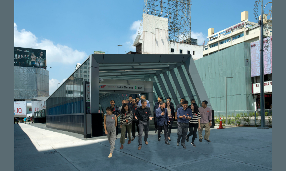
Merdeka Station

In Malaysia, a shift in focus occurred when mass public transport like the LRT arrived and started inspiring people to think about moving responsibly a good two decades ago, which now seems to be an eternity.

“The focus then was on the influx of cars, traffic congestion,” said Ng Yiek Seng, Director of VERITAS Planning Sdn Bhd and VERITAS Architects Sdn Bhd. “If you look at the history of our country, for a long time it was the focus – cars, automobiles.” The aspiration has always been to own them, and likewise, let’s not forget our country’s successful ambition to produce homemade products. Unfortunately, the side effect of this was traffic congestion. Over time, the side dish has taken over the main course – and traffic congestion has to be factored into any scheduling conflicts or cancellations.

But the world has caught up, much more in this part of the world. Ng pointed to mass transit systems, particularly in East Asia, having seen the success of such transit systems in densely populated cities like New York, with its famous subway system, which is the primary mode of transportation for the working class and celebrities.

“In China and Taiwan, they’ve probably doubled what the world has…” You see the transformation of our country, our neighbors…as you see the natural progression of technology and networking across the world “said Edward Chew Fook. Kong, Principal of VERITAS Architects Sdn Bhd, who insisted that it was indeed a natural progression in the integration and interconnectedness that the world was increasingly embracing. plus.”Hopefully with this interconnectedness, there will be less stress and friction between people,” Edward noted. “Culture can be brought together. That’s actually the most important thing about it: connectedness.”

This would explain, if not destroy, the notion of the often increasing, and sometimes waning, popularity of transit-oriented developments (TOD). What are TODs? This definition notes that it is…”an urban development that amplifies the amount of residential, commercial and leisure space within walking distance of public transport. It promotes a symbiotic relationship between the dense urban form and compact, the design and use of public transport.”…which, Hashim notes, has never been off the mark.

“You see, theoretically, the TOD is a very good idea,” he argues. “Because where transport is available, a greater density of people is needed to make the transport system viable. Transport systems are expensive, and the only way for them to be affordable is for everyone to use them. .”

For that, he says, there should be a heavier rollout of TOD and that will only encourage more and more users. “And as a result, it’s starting to pay for itself.”

Hashim continues his pro-TOD assessment by pointing out bluntly that TODs are indeed fantastic for urban planning. So what you have here, instead of spreading a higher density throughout the city, creates a lot of traffic. But by focusing on the nodes, on the transport and on the line, people don’t need to travel by car as much. According to what he says, people would be mostly confined within their own “TOD community”, which is preferably a mixed-use development, with everything practical within easy reach, on foot or by bike, etc. . “You will only use the rapid transit system to get out and meet your family, loved ones, friends, whatever.” The need for private vehicles would become much less… and, who knows, could even disappear”, he fantasizes. long-distance journeys as possible – reduced in the daily schedules of the inhabitants here.

Museum station

Ng, in particular, was very particular about the “in range” part of TODs. “You can have your mamak, your food, you can shop and do everything,” he notes. “Another hundred meters could be where your children can go to school, and within two hundred meters you have hospitals and medical facilities within walking distance, so there’s a good chance that you were also choosing that way of life as a result.”

A change in lifestyle will facilitate a change in mentality. That the number of cars is increasing and clogging the roads is not a problem and has been the norm. But with proper city planning, residents are pushed to think more strategically with the excellent transportation system that can help with all the inconvenience, physical and mental turmoil associated with road rage, disrupted disciplines, and yes, even save thousands of lives that are lost in vehicle tragedies.

But the infrastructure will have to be in place, and it has to be in place quickly! “Increasingly, more people are moving to cities, and by 2050 it is estimated that 70% of the world’s population will be living in cities,” Hashim notes, adding that the same percentage can be expected. here in Malaysia. 70% of the country’s population will move to cities by 2050, it’s hard to believe now, but we’ll be there in thirty years. Can we?

Perhaps if we take a page (or more) from the history of cities around the world, “(Currently in Malaysia), only about 20% of commuters use the rail network.” In developed places like HK, 80% of the population regularly use rail. Similarly, in New York, about 90% use public transportation, Hashim adds. “And, beware, it’s not uncommon to see billionaires in London using rail.”

Big order. There is so much more to do in other departments, not to mention transportation compared to these towns. But we can always take a look at what our neighbors are doing. Singapore, for example, has a long history of dealing with traffic problems through electronic road pricing (ERP), a system in which a charge is imposed at certain times in the busiest areas of the island.

“Imagine in areas of KL, like Sultan Ismail, Ampang, you have an ERP where you have to pay to enter, recharge your Touch N Go… Then it will encourage the use of public transport,” says Hashim.

Hashim, Ng and Edward should know and understand these issues well. VERITAS Design Group has been involved in various and remarkable projects, such as Nusajaya West Master Plan as well as Nusantara (the new capital of Indonesia), and many other projects around the world. VERITAS understands these changes and the direction that is taking place in urban planning.

The biggest change, Ng says, will come over time. In fact, with what is currently the mental map of the Klang Valley filled with crowded snakes and ladders, the future will include a simpler network of stations and public transportation system stops. Hashim pointed to a good example of planning – Paris Mayor Anne Hidalgo, who alongside a strong environmental policy track record has pursued massive transport reform, introducing free public transport for children, electric bikes also free for children, among others.

Pasar Seni Train Station

He noted that we Malaysians are now more concerned with comfort and convenience. “Malaysia, like the rest of the world, is all about convenience and efficiency,” he notes. It’s convenient not having to drive and park your car, while having their Mamak restaurant, Starbucks and movie theaters within walking distance.

When you have all this, he asks, why would you need a car? “Maybe for the weekend,” he thinks. “So you really need a car!” Who knows, with their current status as a massive polluter, source of stress and cause of fatal accidents, cars could now be slowly transitioning into semi-retirement and becoming one of the weekend getaway pleasures that the we wait impatiently. The mention of public transport will hopefully no longer elicit a bitter response.

About VERITAS Design Group

VERITAS Design Group was founded in 1987 on the principles of constant innovation and commitment to the highest standards of professionalism.

Today, VERITAS is led by Founder and Group Chairman David Mizan Hashim and Vice Chairman Lillian Tay, supported by a team of 18 directors in Malaysia and around the world. These leaders are backed by a team of nearly 350 skilled professionals and support staff that make VERITAS one of the top 100 multidisciplinary design practices in the world.

VERITAS, started out as an architectural firm, but now offers a full range of supportive design services for the built environment through subsidiaries. These include interior design, landscaping, planning, environmental consultancy, engineering, quantity surveying, project management and claims consultancy.


This content is provided by Veritas Design Band

Interested in having your ads on Malaysiakini? Contact the announcements team at [email protected] or whatsapp on +60 17-323 0707 for urgent matters.

An expert in urban planning “disappointed” with the exception to the density objectives

“I’m disappointed in the council for not believing in the strength of our official community plan.”

Content of the article

A planning expert says council’s decision to build “flexibility” into density targets for new neighborhoods sets a precedent that points Regina in the wrong direction.

Advertisement 2

Content of the article

“I was really disappointed,” said Vanessa Mathews, an associate professor of geography and environmental studies at the University of Regina who specializes in planning and urban geography, on Thursday.

“I think even just opening up the possibility of large-scale, single-family housing development inaccessible by public transport seems to be a step backwards from where we are actually trying to get to. “

Mathews shared his views at a city council meeting on Wednesday, where a report calling for an amendment to the city’s official community plan to allow waiver of density targets for new neighborhoods in “unique” circumstances was been approved.

Currently, OCP has a density target of 50 people per hectare (pph). The goal of the density target is to prioritize the development of complete neighborhoods that are safe, inclusive, easy to move around, and that offer a “mix of housing choices, amenities and services.”

Advertisement 3

Content of the article

The exception, or ‘flexibility’ as it was often described in Wednesday’s meeting, allows for a lower density requirement based on ‘unique factors’ such as area size, access and limited potential to accommodate neighborhood services.

“The development of these areas would naturally be less diverse and would likely require some trade-off for development in accordance with complete neighborhood policies,” the report said, adding that these situations are “unlikely to be common” and that the overall impact on the OCP would “not be significant.

A map that shows the new districts of the city in orange.
A map that shows the new districts of the city in orange. .jpg

The administration said an area adjacent to the Joanne Goulet Golf Course on Pinkie Road is likely the only site in the city’s growth plan that the policy change would affect, as it “may not be suitable for residential development at 50 pph or more given its smaller size”. development area and limited potential for services such as public transport.

Advertisement 4

Content of the article

“This location is small and would never meet the criteria for a complete community, but could provide some level of opportunity for specific housing options throughout our community,” said Stu Niebergall, President and CEO. the leadership of the Regina & Area Homebuilders Association, in support of the changes.

“OCP is not blowing itself up today,” Niebergall insisted, arguing that the change was insignificant and did not warrant much ideological discussion. “This recommendation simply gives the council and future councils flexibility to move forward.”

But Mathews says the city should under no circumstances consider outward growth that falls far short of the 50 pph target given the inability to meet existing neighborhood intensification targets and the cost high maintenance and connection of the city to these new areas.

Advertisement 5

Content of the article

“Downtown, our goal is to add 10,000 people. Since 2014, we’ve added 81,” Mathews told the council. “Our annual escalation rate in 2021 reached a negative level (-5.2%). We have lost population in established areas.

Reflecting on the council’s decision on Thursday, she said people were disheartened that despite an OCP with clear goals and a recently approved energy and sustainability framework, the city has “so quickly” paved the way for a comeback. to low-density, single-use developments. .

“There’s no reason to create flexibility now in our Official Community Plan and send a message to the people of Regina that the goals we just achieved can easily be exceeded,” Mathews said.

But proponents of the changes argued it was not a slippery slope scenario.

Advertising 6

Content of the article

“It’s not something that’s going to thrive with a bunch of single-family homes,” the adviser said. Lori Bresciani said she supports the amendment, but single-family homes must be an available option in the city.

According to the Regina & Region Home Builders Association (RRHBA), approximately 19% of Regina consumers can afford a single-detached home mortgage based on household income,” the report states. Mathews notes that 63% of housing in Regina is single-detached, according to a 2021 Statistics Canada report.

“I don’t think single family homes are under attack at all,” Mathews said.

While the amendment passed by majority vote, Councilors Dan LeBlanc (Ward 6), Shanon Zachidniak (Ward 8) and Cheryl Stadnichuk (Ward 1) voted against the change.

Advertising 7

Content of the article

Zachidniak argued that while the process would ensure the decision goes through both administration and the board before it is approved, or not, she argued that the board lacks the expertise to judge. when a circumstance might warrant a waiver of the density goal.

“I thought that was a really interesting question to ask not only about current but also future configurations of councils, whether or not they will be able to use their discretion and whether that will support the overall planning goals that we have in the city,” Mathews said Thursday.

The administration said the amended policy would be part of a 10-year review of the OCP scheduled for next year and would be subject to public consultation then.

Stadnichuk also expressed concern about a “political approach by exception.”

Advertising 8

Content of the article

Ultimately, the report passed with Councilors Bob Hawkins (Ward 2), Terina Shaw (Ward 7), John Findura (Ward 5), Jason Mancinelli (Ward 9) and Landon Mohl (Ward 10) voting in favor. .

“I’m disappointed in council for not believing in the strength of our official community plan and for not supporting the goals it recently adopted to become a sustainable city,” Mathews said.

  1. An aerial photo shows downtown Regina including local landmarks such as City Hall, Hill Towers, Court of Queen's Bench, Saskatchewan Hotel, Capital Pointe Hole and the intersection of Albert Street and Victoria Avenue.

    City plans to eliminate intensification tax to spur development

  2. A rental sign is seen on a building in downtown Regina, Saskatchewan on April 21, 2021.

    The executive committee will explore options to increase population growth in the city center

[email protected]

News seems to be flying towards us faster all the time. From COVID-19 updates to politics and crime and everything in between, it can be hard to keep up. With this in mind, the Regina Leader-Post has created a Afternoon titles newsletter that can be sent to your inbox daily to ensure you are up to date with the most vital news of the day. Click here to subscribe.

Advertisement 1

comments

Postmedia is committed to maintaining a lively yet civil discussion forum and encourages all readers to share their views on our articles. Comments can take up to an hour to be moderated before appearing on the site. We ask that you keep your comments relevant and respectful. We have enabled email notifications. You will now receive an email if you receive a reply to your comment, if there is an update to a comment thread you follow, or if a user follows you comments. Visit our Community Rules for more information and details on how to adjust your E-mail settings.

The Urban Planning and Design Software Market Will Reach Big Revenues in the Future

The latest research report on Global Urban Planning and Design Software Market was conducted in a variety of industries in various regions to provide a report containing data exceeding more than 100 pages. The report offers a mix of qualitative and quantifiable information focusing on aspects such as key market developments, gap analysis industry and competitor challenges and new opportunities in the Urban Planning and Design Software market. Various leaders as well as emerging players have been profiled in this report, such as SketchUp, ESRI, Bentley, Holistic City, Lumion, Modelur, SimWalk, UrbanSim, UrbanFootprint, City Form Lab, Urban ROI Designer which constitute an important part of the industry.

The unique point of this report is that it contains import and export policy details which can have an immediate impact on the Global Urban Planning and Design Software Market. Additionally, this study includes EX-IM* related chapters for all concerned companies dealing with Urban Planning and Design Software market and related profiles and renders valuable data in terms of finance, product portfolio, investment planning and marketing and sales strategy. Related graphs and tables of key industry data are available by purchasing this report.

Sample Free Report + All Related Charts & Graphs @ https://www.datalabforecast.com/request-sample/274385-urban-planning-and-design-software-market

(The sample of this report is readily available upon request).
This free sample report includes:
• A brief introduction to the research report.
• Graphical introduction of the regional analysis.
• Top market players with their revenue analysis.
• Selected illustrations of market perspectives and trends.
• Sample report pages.

Market Segmentation: Global Urban Planning and Design Software Market

– Market is based on type, application and geographical segments.
– Based on Type, the market is segmented into Cloud-based, web-based.
– Based on application, the market is segmented into Architects, urban planners, creative services.

Quantifiable data:

• Breakdown of market data by key geography, type and application/end user
• By type (past and forecast)
• Specific applications to the planning and design software market Sales and growth rate (History and forecast)
• Urban planning and design software revenue and growth rate by market (historical and forecast)
• Urban planning and design software market size and growth rate, application and type (past and forecast)
• Urban Planning and Design Software market revenue, volume and year-on-year (base year) growth rate

Find out before you buy this report – https://www.datalabforecast.com/request-enquiry/274385-urban-planning-and-design-software-market

Urban Planning and Design Software Market

Key search: Experts from the global urban planning and design software industry, including management organizations, processing organizations, and analytical service providers that deal with the value chain of industry organizations, have been the main source of data collection. To collect and certify qualitative and quantitative information and determine the outlook, we interviewed all major sources.

Secondary research: Essential information about the industrial value chain, core people and applications have been the focus of secondary research. Market segmentation based on lowest industry level, geographic markets, key market developments, and technology-driven core development has also been done to provide a detailed picture of the current market situation.

Qualitative data: Includes factors affecting or influencing market dynamics and market growth. To list certain names in related sections

• Industry overview
• Growth engine of the global planning and design software market
• Global Urban Planning and Design Software Market Trend
• Incarceration
• Urban planning and design software market opportunity
• Market entropy ** [specially designed to emphasize market aggressiveness]
• Fungal analysis
• Porter Five Army model

Custom specific regional and country reports for the following areas.

North America: United States, Canada and Mexico.
South and Central America: Argentina, Chile and Brazil.
Middle East and Africa: Saudi Arabia, United Arab Emirates, Turkey, Egypt and South Africa.
Europe: UK, France, Italy, Germany, Spain and Russia.
Asia Pacific: India, China, Japan, South Korea, Indonesia, Singapore and Australia.

Buy Full Copy of Global Urban Planning and Design Software Report 2022-2030 @ https://www.datalabforecast.com/buy-now/?id=274385-urban-planning-and-design-software-market&license;_type=su

** Market is valued on a Weighted Average Selling Price (WASP) basis and includes applicable manufacturer taxes. All currency conversions used in the creation of this report have been calculated using a certain 2022 annual average currency conversion rate.

Some of the points covered in the Global Urban Planning and Design Software Market research report are:

Chapter 1: Global Urban Planning and Design Software Market Overview (2017-2030)

• Definition
• Features
• Classification
• Apps
• Regions

Chapter 2: Market Competition by Players/Suppliers 2017 & 2021

• Manufacturing cost structure
• Raw material and suppliers
• Manufacturing process
• Industry chain structure

Chapter 3: Sales (Volume) and Revenue (Value) by Region (2017-2021)

• Sales
• Turnover and market share

Chapter 4, 5 and 6: Global Urban Planning and Design Software Market by Type, Application and Player/Supplier Profiles (2017-2021)

• Market share by type and application
• Growth rate by type and application
• Drivers and opportunities
• Basic company information

Continued……..

Remark : Regional breakdown and purchase by section available We provide Cats Pie Best customization of reports as per requirements.

Contact:
Henry K.
Data Lab Forecasts
86 Van Wagenen Avenue, Jersey,
New Jersey 07306, USA
Phone: +1 917-725-5253
E-mail: [email protected]
Website: https://www.datalabforecast.com/
Follow us on: LinkedIn | Twitter |

More trend reports by Data Lab Forecast:

  • Global Concrete Expansion Joints Market Overview, Forecast to 2027
  • Global Inventory Management Software Market Size, Status and Forecast 2021-2027
  • Global Mammalian Cell Culture Market Overview, Forecast to 2027

What is “PlanningTok?” The amazing world of TikTok city planning

During her first semester of graduate studies, Brad Biehl noticed a problem.

He had studied entrepreneurship as an undergraduate, but a life-changing internship set him on a whole new path. It turned out that his true calling was town planning – a career he barely knew existed a few years earlier.

“I realized that planning, design and urban planning were sort of at the crossroads of everything that interested me,” Biehl told In The Know.

Biehl quickly entered a master’s program in urban planning. But at the start of class, he found his teachers all complaining about the same problem – what Biehl calls an “existential communication problem”.

Urban planners have the power to make radical decisions about how and where we live. They design green spaces, design new neighborhoods and revitalize declining neighborhoods. They work with governmentsmassive construction companies, local residents and more to bring education, transportation, sustainability and access to our cities.

And despite all that power, hardly anyone knows what they’re doing.

“There are people who design things, people who have ideas, who work together, but they fail to engage people proactively or retroactively,” Biehl said.

Biehl’s professors described an industry with a major disconnect between planners and people – those who make the decisions and those who are affected by them.

So, Biehl thought, why not bring urbanism directly to people? It turned out that other planners shared the same idea.

Biehl is now part of “PlanningTok” (also known as “CitiesTok”), a thriving group of urban planners, architects and civil engineers using TikTok to change the way we talk about the places we live.

While the topics may seem straight out of a college course, the appeal is much, much broader. Biehl, who publishes as @citiesforpeople, has more than 11,000 subscribers. Many of his clips attract hundreds of thousands of views.

“Most people… see it for the first time”

Some users, like Paul Stout, can capture millions of viewers at once. Stout, who works for the urban development firm culdesacbegan posting on TikTok in the spring of 2021.

When Stout started his page, @talkingcities, he was one of the first city planners to use the platform to explain how cities can become more walkable, more equitable and more sustainable. His videos often look at the success stories of well-designed cities around the world.

Like Biehl, Stout became obsessed with urban planning near the end of college. And soon, he realized that TikTok was the best forum to talk about it. As he told In The Know, he was struck by the platform’s “low barrier to creation”.

It was easy to make his videos, which often use little more than a graphic or simple photos of cities. And the payoff, Stout realized, was enormous. With these easy-to-process examples, he was able to get viewers thinking about the possibilities for their own cities.

“It’s one of the places where social media can really help,” he said. “Because people can look at things and say, ‘Huh, that’s phenomenal. I want one in my condition.

In many ways, TikTok users represent the next generation of city dwellers. Despite its ubiquity, the app’s audience is still extremely young, with 62% active users be 29 or younger.

A typical PlanningTok viewer may be leaving their parents’ home for the first time – for college, a new job, or a myriad of other reasons. And they are likely to do so in a city.

American cities have been rejuvenate during the last years. In 2016, the average age of people living in urban areas was 36 years oldagainst an average age of 43 for rural areas.

Stout sees this as a major opportunity. His videos aren’t meant to be exhaustive, but they can serve as an introduction, especially for those who are just beginning to think critically about living in a city.

“Most people seeing this content are seeing it for the first time,” Stout said.

A “gateway” to urban planning

That doesn’t mean PlanningTok is the be-all and end-all. In fact, Biehl sees his content as a “gateway,” through which he can use urbanism to open up broader conversations – about the environment, the economy, health, diversity and more.

Stout has a similar design. Its content is not exhaustive, but it is a starting point.

“The zoning policy is very complicated,” he said. “And it’s like if you want to do a quick 30-second intro to zoning, you’ve got a lot to hit. And there’s a lot of stuff that will be left out. But at least people can get to grips with a bit with the subject and maybe do some research on their own.

Brittany Simmons, a New York-based urban planner who posts as @signedbritt, believes that these starting points can turn into real change. Her goal, as she puts it, is to show that “urban planning doesn’t happen by accident” — that there are real people behind the forces that shape our cities.

“These are things that happen that most of us assume we have no say in,” she said. “But you can actually be engaged and involved in the processes.”

There are countless ways people can participate in their city’s planning decisions – from attending conferences and city council meetings to joining local community groups and organizing with neighbors.

Simmons, who went to graduate school in urban planning, first got on TikTok with no intention of posting about her work. But when she posted a video asking his followers if they knew what urban planning was, the results were overwhelming.

“People were really excited, which really surprised me, mainly because it’s an area that nobody knows about,” Simmons said.

Soon, she was inundated with questions from users — many in middle or high school — asking for more details about her work.

“I just didn’t know it existed”

For planners, this is another huge advantage of PlanningTok. Because creators aren’t just broadening minds about how cities work, they’re also bringing transparency to a largely unknown career path.

Simmons said that transparency is now an explicit goal of his account. She sees TikTok as a chance to get young people interested in her industry. Some of them, she hopes, might even become planners themselves one day.

“Historically there was a lot of mystification around the pitch, and it’s always been really exclusive,” Simmons added.

The most recent statistics show that, despite progress, almost 76% urban and regional planners are white. The average worker is in his early to mid 40’s.

It’s possible that PlanningTok can help correct this disparity. Simmons, Stout and Biehl all said they received messages from young people saying they were interested in the field.

“I didn’t really know [these jobs] until I was late for college,” Biehl said. “Part of the motivation for making these videos is that, if I had seen them when I was 17, my trajectory would have been different.”

Simmons added that her own career has also been shaped by this lack of knowledge.

“I can’t say, ‘Oh, I’ve wanted to be a planner since I was a kid,’” she told In The Know. “Really, like most people, I just didn’t know it existed.”

Like most of PlanningTok’s main creators, Simmons, Biehl and Stout are younger. They are at the start of their careers, only a few years away from the eye-opening experiences that brought them to the field.

Simmons said she sees her age as a major strength because her younger viewers can still relate to what she’s going through. His hope is to show that “cities don’t just happen,” and if people want to make a difference, they can, either through their work or as members of their communities.

“If cities or development or things that happen in your community are something you care about, it’s something you can engage in professionally,” Simmons said. “But if you don’t want to get into it professionally, you can just be someone who is more involved in the processes that are happening locally.”

More from In The Know:

Airline Passenger Shows What It’s Like To Fly In A ‘Business Class Only’ Luxury Plane

My Dentist Told Me To Use This $10 Tongue Cleaner To Get Rid Of Morning Breath Forever – And It Worked

5 Soft and Flattering Sweaters Under $50 at Nordstrom to Buy Now and Wear Year-Round

This coconut ice cream is the perfect summer treat

Listen to the latest episode of our pop culture podcast, We Should Talk:

Urban planning theory is ripe for an overhaul, as ‘2040’ court ruling and pandemic show

Although well-intentioned, current planning theory and the Minneapolis 2040 plan fail in their purpose. The district court’s decision last week in Smart Growth Minnesota v. Minneapolis, which halted implementation of the 2040 plan for environmental reasons, is only the most recent evidence of the problems with using planning theory to address social justice or environmental issues.

Urban planning, urban planning theory and urban design follow trends. Among the hottest theories in recent years have been a push for increased urban density through the elimination of single-family zoning and a call for greater reliance on more public transit to move people around. people. The two goals are to provide more affordable housing, eliminate racial and economic segregation, and protect the environment. This was the design of the Minneapolis 2040 Comprehensive Plan, which was nationally announced as a progressive planning model.

The article continues after the ad

From the late 19th century until the 1950s, the trend was for rapid urbanization in America as people left the farms for the cities. Industrialization, improved sanitation, and economic opportunity have led to this. Yet this urbanization has been accompanied by racial pacts and segregation, including Minneapolis and maybe St. Paul.

But post-World War II suburban America was born. It was the product of aging urban infrastructure, the lure of cheap land in the suburbs, the rise of the automobile and massive highway construction, and white flight. The cities became depopulated and the suburbs became the new centers of population. Metropolitan areas have become racially and economically segregated, as described among others by Douglas Massey and Nancy Denton in American Apartheid. Twenty-five years ago, a team of researchers, including myself, highlighted the Twin Cities as one of the most segregated urban areas in America.

But about a generation ago New Urbanism as a theory of planning emerged. Inspired by the Jane Jacobs classic The Death and Life of America’s Big Cities, New Urbanism said suburban sprawl was economically inefficient, allowed racial and economic segregation, and was bad for the environment. Sprawl has wasted land or encouraged reliance on cars, often occupied by single commuters. Cities were generators of complexity, and to be successful they did not have to mimic suburbs heavily reliant on single-family homes over large spaces. The New Urbanism proclaims “Return to the city”; densification is good, and creating more transit options is the best way to get people around.

People returned to cities, including Minneapolis and St. Paul, but it didn’t come without problems. The underlying racial and economic segregation that existed in cities was not alleviated by the return of aging suburbs of baby boomers or Millennials and Gen Z who wanted to live there. In fact, the redensification of cities has led to the gentrification of neighborhoods with concentrations of poor people or people of color. Rents accelerated, housing prices rose, and suddenly cities faced massive affordability crises. This too is the history of Minneapolis and St. Paul, who have the worst housing shortage between the metropolitan regions of the country.

In an effort to address these issues, Minneapolis primarily and St. Paul to a lesser extent have acted. The Minneapolis 2040 Comprehensive Plan sought to address this issue by removal of single-family zoning. Allowing up to three units per property and it is believed would increase housing supply, and with more units it would solve the affordability crisis and promote desegregation.

Yet, that did not happen. On the one hand, housing is not a unified but diversified market. Housing built for the rich or middle class is not the same as housing built for the poor. All other things being equal, developers will build the type of housing that is most profitable for them, and it is not for the poor. While some argue that simply increasing the supply of housing lower overall housing costs, there is mixed evidence for this, especially for low-income households.

Second, the housing market is driven by demand from renters and owners. But housing also has a national market, driven by investors looking for opportunities to make money. Preliminary studies pointed out how the zoning change has driven up housing costs in low-income Minneapolis neighborhoods — an early sign of speculation and gentrification. As the Washington Post pointed out in his analysis of housing markets in the United States, including Minneapolis, domestic investors are gobbling up housing in North Minneapolis because the real estate is relatively cheap and they can easily turn it into apartment buildings at multiple dwellings. As a result, people of color in North Minneapolis are losing homes and apartments to investors with little indication that the housing replacing it is affordable or racially integrated. Studies point to the fact that home ownership is inaccessible to black familiesincluding in the Twin towns. This is the first notion of gentrification.

Moreover, densification does not break racial or economic segregation and does not necessarily lead to more affordable housing, according to a recent article by Governance Magazine. Densification does not address mortgage discrimination, which persists in Minneapolis according to the Federal Reserve. There are few indications that expensive single-family homes in south Minneapolis are being divided into affordable housing. Densification may encourage business growth, but it does little to alleviate segregation or provide more affordable housing for those who need it most.

The article continues after the ad

Additionally, as Hennepin District Judge Joseph Klein pointed out in his June 15 ruling on the Minneapolis 2040 plan, increased densification potentially brings with it a host of environmental issues that have not been properly considered. when it is adopted. The City must think about it if it wants to proceed with the elimination of single-family zoning and greater densification.

Now consider the impact of COVID on urban design and planning. At the height of the pandemic, people were told to avoid public transport and work from home. This has been made possible for many, especially the middle class and above, by telecommuting. As the pandemic subsides, studies are being conducted by the Urban Institute and others according to a American Transit Association report.

In addition, many have fled the cities to suburb or even more remote locations to find cheaper and more spacious accommodation, and there is evidence many are not returning and many companies are considering more remote working in the future. This corresponds to a recent Survey on working methods and attitudes finding a generational and permanent shift in views towards hybrid and remote working. People have fled cities to escape the pandemic. From a public health perspective, the suburbs suddenly look like safer places.

David Schultz

But at least in the Midwest, planners and politicians forgot something else: People still want to own a home. Surveys reveal that home ownership is still part of the American dream for many. Home ownership is the most important asset that many people have and it is the key to becoming part of the middle class. Home ownership, while perhaps not for everyone, serves an important set of interests.

Several years ago, I chaired a panel for an American Planning Association regional conference examining the wisdom of Minneapolis’ elimination of single-family zoning. A person from the Met Council proclaimed: ‘We have more single-family housing than we need in the metropolitan area.’ When asked if such housing was affordable or available in the metropolitan area, there was no response.

There is a housing problem in the Twin Cities metropolitan area. Something needs to be done, but the planning fixes currently in use will not solve the segregation and affordability issues. Moreover, planning theory and urban design have yet to recognize a new reality that the pandemic has produced. Public health factors must be taken into account in the design of buildings and transport and in the planning of cities. Density, as some studies point out, may not be the right answer in the future if we have to deal with future pandemics. Finally, the pandemic has shown how working from home can also reverse the desire or need to provide more public transport or to build housing exclusively in traditional urban centers.

The article continues after the ad

David Schultz is Emeritus Professor of Political Science at Hamline University. Previously, he served as city manager of planning, zoning and code enforcement and as a housing and economic planner for a community action agency.