Shanghai’s reopened urban planning center sells out

Shot by Jiang Xiaowei. Edited by Jiang Xiaowei. Subtitles by Yang Jian.

Shanghai’s iconic urban planning exhibition hall reopened to the public for free on Tuesday after a nearly two-year renovation.

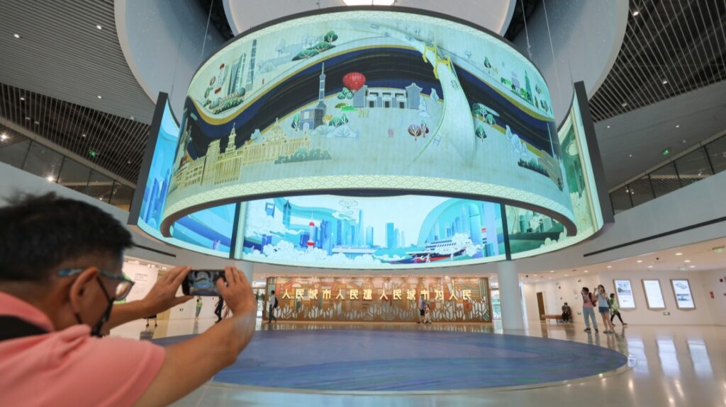
The Shanghai Urban Planning Exhibition Center on People’s Avenue in Huangpu District has integrated new technologies, such as virtual reality, augmented reality, 8K high-definition displays as well as the largest five-dimensional digital map of the world to present the past, present and future development.

It is open free of charge from 9 a.m. to 5 p.m. every day, except Wednesday. Visitors must make online reservations and have a negative polymerase chain reaction test result within the previous 72 hours.

All 500 quotas for the first day were reserved immediately after the center announced the reopening on its official WeChat account.

“I think it’s the best place for children to learn about the history and the future of the city,” said Pan Hong’an, a local pensioner who took his grandson to the center around 10 a.m. Tuesday.

“The new exhibition includes many high-tech facilities that well represent Shanghai’s status as a center of scientific innovation.”

The center closed on December 1, 2019, for its biggest facelift since the venue opened in February 2000.

During its more than two decades of operation, the center has received a total of 7.2 million visitors, 60% of them from abroad. Many foreign tourists have chosen the center as the first stop on their visit to Shanghai, according to the center.

It is the first exhibition center in China dedicated to urban planning and construction achievements.

The center was supposed to reopen in March, but that was delayed by the resurgence of the COVID-19 pandemic.

The new exhibition center mainly presents the city’s 2035 master plan in several thematic exhibitions such as “humanist”, “innovation” and “ecological”.

The miniature models reproduce the typical characteristics of the city shikumenor stone residences, as well as popular water towns such as Zhujiajiao in suburban Qingpu District.

Shanghai’s latest digital transformation strategy and smart digital applications are also on display with interactive installations.

A section has been designated for professionals to view the latest global planning information and details of Shanghai’s previous master plans.

Over 500 photographs, 90 videos and 40 models are featured in around 30 exhibits, which will be regularly updated to include the latest in city planning.

A section on the ground floor will host temporary art exhibitions related to urban studies.

Currently, the inaugural exhibition – Beijing-Shanghai Urban Culture Image Studies – runs until September 10.

More than 40 photos taken by 30 architects and urban planners in the two cities address many key urban development issues, such as convergence of urban styles and lack of features, according to the exhibition organizer.

Kaumatua needs a role in city planning

Photo: Radio Waatea Image Database.

Tuwhenuaroa Natanahira

Diane Turner: Kaumatua needs a role in city planning

The Office for Elders wants city planners to make their spaces suitable for everyone, including kuia and kaumātua.

According to director Diane Turner, New Zealand is reaching the point where one in five people will be over 65.

She says older people often feel left out of conversations about development.

The office’s new urban planning report offers advice on improving streets and public spaces, accessibility and ease of movement, housing, and how best to connect older people to their community through design.

“It’s about having a sense of place and belonging and kaumātua and kuia will often have a deep knowledge of the local landscape, its history and a desire to share those stories, and it’s important to provide a sense of ownership that these stories are shared in our urban development and urban design,” says Ms. Turner.


A hope for climate-focused urban planning in Assam cities

  • As cities grow rapidly, drainage systems are not developed accordingly, leading to prolonged flooding during heavy rains.
  • The National Institute of Urban Affairs (NIUA) in New Delhi is insisting on facilitating groundwater recharge to store excess flood waters.
  • The Assam State Action Plan 2.0, which is pending approval, focuses on mainstreaming climate action into infrastructure, governance and urban policies.

“I was waist deep in water,” recalls Tarun Rajkhowa, a 70-year-old resident of Guwahati city’s Rukminigaon district. In mid-June this year, when incessant rain flooded parts of the city, Rajkhowa and his wife were stuck in their first-floor apartment for almost a week. “It was impossible for us to go out. The relief material was delivered to us by boat. The vehicles parked on the ground floor of our building were completely under water,” Rajkhowa said. Just weeks after a severe wave of flooding in May, heavy rains left the town of Silchar in southern Assam inundated for days for the second time.

Rain-triggered floods have caused widespread havoc in rural Assam in recent years. However, this year, crucial urban areas such as Silchar and Guwahati were considered the most affected. As large numbers of people migrate to cities, experts say there is a lack of urban planning and resources to support burgeoning populations, making these cities vulnerable to climate impacts, natural disasters , floods and landslides. A government study of 12 states in India’s Himalayan Region (IHR) and their vulnerability to climate change found Assam to be among the most vulnerable states.

The challenges of urban planning

Dulumoni Kakati, Councilor of Guwahati Municipal Corporation (GMC), confirmed that increased construction, urbanization and inadequate waste disposal systems are some of the reasons why many areas in Guwahati are experiencing floods. Calling for better drainage systems, she explained that when rainfall is low, flooding is usually not a risk. But intense rains, as seen in June, overwhelm the city’s drainage.

Abhijit Sharma, president of the northeast branch of Institute of Town Planners, said: ‘We have no local planning – no parks, no open spaces, no drainage systems. The municipal corporation is a people-oriented institution, but somehow it is not given enough importance.

He also says there is not enough land in the cities to meet the needs of those who migrate from smaller areas in search of livelihood opportunities, especially those who are economically and socially marginalized. “A lot of these people have settled in the hills and this has led to earth cuts, which later clog the sewers in the cities. An urban plan would help these people. We tell them not to go to the hills but where will they stay Most people who migrate are poor.

An aerial view of Golaghat, Assam. Increased construction, urbanization, and improper waste disposal systems are some of the reasons why many cities witness flooding. Photo by OmerMarcel/Wikimedia Commons.

A lack of clean pipes and a persistent misunderstanding of citizens, he added, are manifestations of larger problems.

Parthankar Choudhury, a professor of environmental science at the University of Assam in Silchar, points out that while people living in one-story houses have suffered greatly, marginalized communities are going through tougher times.

Experts say that the rapid concreting of surfaces and the growth of infrastructure hinder the absorption of rainwater into the ground. “Due to the increase in infrastructure, rainwater accumulates very early in cities,” said Ratnakar Mahajan, technical director at Maccaferri India, which focuses on advanced solutions for mining engineering projects. and environmental.


Read more: More research on the relationship between flash floods and climate change is needed


The National Institute of Urban Affairs (NIUA) in New Delhi also emphasizes facilitating groundwater recharge to store excess flood waters. “We are emphasizing the proper management of ponds, lakes and other water bodies that will serve as retention basins during floods,” said Hitesh Vaidya, Director of NIUA.

Mahajan thinks that drainage systems are not developed while cities are growing rapidly. Drainage patterns should be modified according to the natural flow of water. “The drains need to be resized – they should be bigger. The precipitation regime changes, so drainage systems must be studied and properly planned.

The role of government

Rizwan Uz Zaman, Technical Consultant at Assam Climate Change Management Society (ACCMS), discussed several initiatives recently undertaken by the government, including the State 2.0 Action Plan which was endorsed by the Assam Cabinet and is awaiting approval from New Delhi. “The water resources department came up with many measures, and the housing and urban affairs departments also came up with new initiatives. Innovative climate resilient actions have been suggested for flood management in cities. The document is not yet public and we will only be able to share it once it has received approval from New Delhi. We consult civil society and experts in the field.

According to Zaman, the Assam State Action Plan on Climate Change 2.0 mainly focuses on mainstreaming climate action into urban governance and policy, construction of urban housing and climate-resilient waste management, a low-carbon road network and mobility, and ensuring holistic pollution/emissions management. in the towns. “Those are the five big strategies we are working on. The forest department has also taken the initiative to rehabilitate and resettle forest dwellers from various places.

The image shows an aerial view of Guwahati, India
The rapid concretion of surfaces and the growth of infrastructures hinder the absorption of rainwater into the ground. Photo by Anushila Bharali/Wikimedia Commons.

Hrishiraj Sharma, an architect and urban planner based in Guwahati, said: “The water comes from the hills to the cities. The city can only draw water according to its capacity. Apart from this, if the excess water comes from the hills, the water levels in the valley will rise.

NIA Director Vaidya said cities in the northeast are no different from others in India when it comes to typical shortcomings in urban planning. Among those shortcomings, he noted, was the reluctance to adopt a systematic approach. This can be attributed to a lack of coordination and interaction with communities and the general public. “In most cases, public opinion is only sought after the plans are prepared,” Vaidya said. He also highlighted the need for more urban practitioners and public officials to develop ways to take an approach that takes climate resilience into account. “We need to move from a relief-centric approach to a proactive response-centric approach to dealing with extreme and more frequent disasters by building climate-resilient infrastructure.”

Experts also suggested that the municipal corporation and district administration conduct a carrying capacity survey in towns and villages in Assam, which can give an idea of ​​the population a town can support with its resources.

Mongabay-India has contacted the GMC commissioner for an interview but has not received a response as of press time.


Read more: Extreme flooding from intense cyclones will affect more people in India and Bangladesh


Banner image: Southeast Asia receives heavy rainfall, which makes cities in the northeast, such as Guwahati, particularly prone to flooding. Photo by lensnmatter/Wikimedia Commons.

In memory of Peter Marcuse, influential professor of urban planning

Beginning at the End: As groundbreaking urban planner Peter Marcuse took his last breaths on March 4, 2022, he returned to the language of his childhood to offer his last words to his loved ones. Ich habe etwas zu sagen. (“I have something to say.”). I guess life hasn’t allowed him to finish his thought, but the statement stands nonetheless: Peter Marcuse had something to say, and he said it beautifully and powerfully in his 93 years. on earth.

Peter was born in Berlin, but when he was six his parents, mathematician Sophie Wertheim and Marxist philosopher Herbert Marcuse, fled the Nazi regime, taking Peter first to Switzerland and then to the United States. Peter has become one of the world’s foremost and most influential scholars of radical urbanism, merging his research interests in housing, land use and public space with his political commitments to establishing rights. civilians, empowering tenants and ending homelessness. . He helped found important and enduring institutions of left-wing urbanism like Planners for Equal Opportunity (now Planners Network), and he has tirelessly offered his time and energy to grassroots projects for the realization of the right to the city.

I knew Peter first through his published texts, then as a teacher, and finally as a mutual sounding board and collaborator. In graduate school, I encountered his scholarly writing, always theoretically and empirically rigorous but readable and relatable. In a course on urban sustainability, we read “Sustainability Is Not Enough,” his short essay deconstructing and ultimately shattering the concept of sustainability itself. He argued that the subject matter was inherently conservative; for the earth to survive, our relationship with it – and, just as importantly, with each other – would have to be radically altered.

While attending Hunter College, I started working as an organizer at Tenants & Neighbors. During my first few weeks on the job, I found in a binder a draft of an article by Peter entitled “The Political Economy of Rent Control: Theory and Strategy”, sent for comment to the founder of the organization in March 1977. In it, Peter argued that rent control as we know it is not a gift from a mythical “benevolent state”, but rather a reflection of the balance of power between landlords, tenants and the state. Rent control, he argued, is an important protection for tenants, but also allows landlords to benefit from a virtually guaranteed constant increase in rents, even when market rate rents fall – a dynamic confirmed. in cities like New York during the first year of the pandemic, when rents for market-priced apartments fell, but rent-stabilized apartments either held steady or increased.

While working at Tenants & Neighbors, I took Peter’s course “The Housing Question,” co-taught with fellow left-wing urban planner Tom Angotti, at the Brecht Forum, a Marxist adult education center in New York City. . Peter had long since retired from Columbia University, but he continued to devote himself to educating activists, emerging critics, and curious urbanites seeking deeper answers about why our cities work. as they do. He didn’t attribute much of his own work, but we did read one of his articles called “The Five Lives of Public Housing”, in which Peter demonstrated how the purpose of public housing had changed over the decades, leading to changes in its funding. levels, design and rental. It was classic Marcuse: he took a piece of the built environment that we all thought we knew well and showed us that, in fact, it was many other things at once and still the product of a struggle keep on going.

Over the past few years, Peter and I have sometimes discussed and collaborated on projects and panels. He would ask me for my thoughts on various topics, and I would do the same. Whenever I received an email from him, I always wondered: why is he talking to me? The truth was that Peter was an incredibly generous person who never stopped teaching, but he never stopped asking questions. He always sought to pass on his own knowledge and to draw inspiration from younger generations. He was a model for retiring from his career without ever ceasing to learn, to question, to observe and to make offerings.

Coming back to the end: Peter said his last words – “I have something to say” – on March 4th. That day was my paternal grandfather’s birthday. He used to joke that it was the only date on the calendar that made up a complete sentence in English: “March forward!” Peter met his wife, Frances, at a May Day march and would continue to be part of the protests as long as he could comfortably walk. The date of Peter’s death serves as a final challenge to radical planners, architects and urban planners: march and build a better world than the one we inhabit today.

Samuel Stein is a researcher, writer, advocate, and critic focused on the intersection of real estate and urban planning in New York City and the author of the book Capital: gentrification and state of real estate.

Open doctoral position in (urban) history of town planning and history of construction (4 years) job with UNIVERSITE LIBRE DE BRUXELLES

Research project:
This vacancy is part of the EOS Construction History, Above and Beyond research project. What History Can Do for Construction History, led by Professors Michiel Dehaene (UGent), Dave De ruysscher (VUB, University of Tilburg), Rika Devos (ULB), Johan Lagae (UGent), Stephanie Van de Voorde (VUB) and Ine Wouters (VUB). A total of 3 PhD positions and 4 postdoc positions are included in this project. An overview of the complete project and all relevant mandates can be viewed at: www.vub.be/arch/project/eos. The EOS research project will establish a dialogue (in terms of sources, methodologies, concepts and cognitive interests) between the history of construction and three other fields of history, namely colonial history, legal history and planning history. As such, the project aims to strengthen the historical dimension of construction history, while simultaneously demonstrating its relevance and potential for other fields and disciplines. The project focuses broadly on selected aspects of 19th and 20th century construction knowledge and practices in Belgium and its former colony, with particular attention to tacit knowledge, in order to express actors, sources and types of crucial but underestimated knowledge. The individual trajectory of each doctoral student is part of this extended team, operating in the 3 universities (ULB, UGent and VUB). Intensive exchanges and shared results between team members are crucial for the success of the project. The doctoral positions are each situated in one of the 3 fields of dialogue: (1) history of the construction of colonial history; (2) the legal history of construction and (3) the planning history of construction history. This specific vacancy is issued by the Free University of Brussels (ULB) and engages the dialogue between the history of town planning and the history of construction. It is co-supervised by the teachers. Rika Devos (ULB) and Michiel Dehaene (UGhent). The doctorate is planned as a joint doctorate between the two universities.

The dialogue between the history of town planning and the history of construction will focus on the specific demands produced by the process of metropolitan transformation in the 20th century, both in the formation and in the expansion of the urban agglomerations of Brussels, Antwerp and Liège during the inter-war period and the inter-war period. Glorious Thirties. This sub-team studies the response of the construction industry to the specific demands of remodeling the urban geography and its building stock and the resulting relationships between contractors, architects and emerging developers. It analyzes both the local interaction of these actors and their organization into professional networks.

This doctoral thesis focuses on the specific demands produced by the process of metropolitan transformation in the 20th century.both in the formation and expansion of the urban agglomerations of Brussels, Antwerp and Liège during the interwar period and Glorious Thirties. The context of the study is shaped by the construction industry’s response to specific demands for reshaping urban geography and its building stock and the resulting relationships between contractors, architects and emerging developers. It analyzes both the local interaction of these actors and their organization into professional networks.

More specifically, the study explores the relationship between pioneer activity on the outskirts and the remodeling of the urban core. From previous research at UGent, we know that the same actors engaged in the development of virgin land development were also active in projects aimed at the densification and renovation of the existing city, bringing not only models development but also specific institutional and technical capacities. The doctoral course focuses in particular on three configurations: (1) The role of contractors in the construction of major metropolitan programs, starting from the fringe (eg Van Riel & Van den Bergh in Antwerp); (2) The emergence of development groups specific to Brussels producing certain typical components of the post-war city (supermarkets, service stations, large apartments); (3) Public-private development coalitions that combined investment in infrastructure with renewal of the urban core in Liège. The successful candidate will be based alternately at ULB and UGent, in order to allow dynamic interaction with team members and full integration into both institutions.

Urban planning students on strike for fall reading week

The students unanimously voted in general assembly to strike from October 3 to 7

The Urban Planning Association is the first student association to vote for a fall strike. Courtesy of the Planning Association

Urban Planning Association students voted unanimously in favor of a reading week in the fall of 2022. It is the first student association to call for a strike in October.

Although the Concordia Senate has approved a reading week in the fall of 2021, the policy change will not take place until the fall of 2023. The UPA has decided to go ahead with a strike, demanding that changes be made at a faster pace.

The motion took place at the general meeting of the association on August 15. All eligible students present voted to strike during the first week of October. The leaders of the UPA are convinced that their association will not act alone during the strike.

“We are the first [Member Association] to make this motion and hopefully others will follow,” said UPA Vice President Administration Trynity Turnbull.

Turnbull cited one of the main reasons for the association’s strike: the end of the schedule stalemate due to the pandemic. “Because of [administration’s] continuous changes in the school calendar, there is not much reason to wait,” she said. If the administration could make quick adjustments for COVID-19, it could do so during a fall reading week, she explained.

Vice-President of Internal/External Affairs, Téa Boissoneault, highlighted how the pandemic has impacted the mental health of students. “Everyone has been through such a tough time dealing with exhaustion during COVID,” she said, adding that a break would allow students to replenish their energy.

“It’s not fair that all major universities in Quebec have a fall reading week while we’re stuck in the classroom,” said UPA President Torben Laux. He thanked the students for voting unanimously to strike in the fall, noting his excitement for the upcoming academic year.

According to Payton Mitchell, communications coordinator for the Faculty of Associations and Arts, several other MAs are also considering going on strike. “UPA is the first of many ASFA member associations planning to vote for the class strike in October to take a well-deserved break from academic responsibilities,” she said.

“ASFA encourages all arts and science students interested in mobilizing their department’s association to participate in the strike to contact either on instagram or by contacting Engagement Coordinator Ashley Torres directly at [email protected]“Mitchell added.

Explained: Encroachment and poor urban planning add to Delhi’s congestion problems

Deputy Chief Minister Manish Sisodia called a meeting to discuss the problematic points at 8 p.m. Earlier, the agencies responsible for the roads – PWD, MCD and NDMC – said they were ready for the rains and the drains had been desilted on schedule. The rains, however, laid bare that claim.

Central and South East Delhi were the hardest hit with Teen Murti Marg, Mother Teresa Crescent, Tughlak Road, Pul Prahladpur, Sarita Vihar and Baradpur recording the peak number of complaints.

Why are Delhi’s roads waterlogged?

Over the years, Delhi’s drainage system has become plagued by encroachment and poor planning. Most of the capital’s storm drains are those that have been dug by the natural flow of water over hundreds of years. With the unplanned development taking place in the capital, many of them have been encroached, covered and obstructed. This means that the water no longer had an outlet. To add to the problems, several sewage systems have been mixed with storm sewers and when it rains, the system is overwhelmed.

Concretization also has an important role to play, with very little free space remaining where water can be absorbed into the earth. These concerns have been raised by the city’s environmental and water experts for decades, but no resolution has been forthcoming.

Delhi Congestion Solutions

For several years now, the Delhi government has been planning to put in place a drainage master plan which will work on revamping roads, cleaning major storm drains, disconnecting sewer lines from water mains storms, among other problems, to rid Delhi of annual difficulties.

PWD had launched calls for tenders to appoint consultants responsible for providing solutions to the problems encountered in the evacuation of water. This was supposed to happen in March, but only two bidders showed up and both were rejected by the assessor. A new call for tenders was then launched in May. The consultant must provide workable and feasible solutions, as well as a roadmap for engineering solutions.

“The scope of work will include consideration of parameters to improve the drainage network of the Najafgarh basin under the jurisdiction of Delhi. Once appointed, the consultancy firm will provide solutions for drainage and individual locations, as well as at macro level,” an official told The Indian Express.

Consultants will also review existing pipelines, drains and other storm water drainage systems at all likely waterlogging locations and reverse drain level, road levels. Adjoining soil levels will be raised to provide effective drainage solutions (without siltation conditions). In addition to this, the consultants will also carry out a hydraulic study and assess the environmental impact and prepare a detailed project providing drainage solutions at different levels, as well as drains and an estimate of construction works.

Urban planning and design software market expected to reach $43.33 billion by the end of 2031-SketchUp, City Form Lab, ESRI, Holistic City, Lumion, Bentley, UrbanSim, Modelur, UrbanFootprint, SimWalk, Urban ROI Designer

New Jersey, United States,- The latest report published by MRI Accuracy Reports indicates that the Urban planning and design software The market is expected to accelerate strongly in the coming years. Analysts have studied market drivers, restraints, risks, and opportunities in the global market. The Urban Planning and Design Software Market report shows the probable direction of the market in the coming years along with its estimations. An accurate study aims to understand the market price. By analyzing the competitive landscape, the authors of the report have made excellent efforts to help readers understand the key business tactics that major companies are using to maintain market sustainability.

Key Players Mentioned in the Urban Planning and Design Software Market Research Report: SketchUp, City Form Lab, ESRI, Holistic City, Lumion, Bentley, UrbanSim, Modelur, UrbanFootprint, SimWalk, Urban ROI Designer

Get a sample full PDF copy of the report: (Including complete table of contents, list of tables and figures, chart) @ https://www.maccuracyreports.com/report-sample/192676

The report includes company profiles of nearly all major players in the Urban Planning and Design Software Market. The Company Profiles section provides valuable analysis of strengths and weaknesses, business trends, recent advances, mergers and acquisitions, expansion plans, global presence, market presence and portfolios of products from major market players. This information can be used by players and other market participants to maximize their profitability and streamline their business strategies. Our competitive analysis also provides vital information that will help new entrants identify barriers to entry and assess the level of competitiveness in the Urban Planning and Design Software market.

Urban Planning and Design Software Market

.

Application as below

Architects, urban planners, creative services

The global planning and design software market is segmented on the basis of product and type. All of these segments were studied individually. The detailed investigation helps to evaluate the factors influencing the Urban Planning and Design Software market. Experts analyzed the nature of development, investments in research and development, changing consumption patterns and the growing number of applications. Additionally, analysts have also assessed the shifting economy around the urban planning and design software market which is likely to affect its development.

The regional analysis section of the report enables players to focus on high growth regions and countries that could help them expand their presence in the Urban Planning and Design Software market. Besides expanding their footprint in the Urban Planning and Design Software market, the regional analysis helps players to increase their sales while having a better understanding of customer behavior in specific regions and countries. The report provides CAGR, revenue, production, consumption and other important statistics and figures related to global and regional markets. It shows how different types, applications, and regional segments are advancing in the Urban Planning and Design Software market in terms of growth.

Scope of Urban Planning and Design Software Market Report

ESTIMATED YEAR 2022

REFERENCE YEAR 2021

FORECAST YEAR 2029

HISTORICAL YEAR 2020

UNIT Value (Million USD/Billion)

The Urban Planning and Design Software report provides information on the market area, which is sub-divided into sub-regions and countries/regions. In addition to the market share in each country and sub-region, this chapter of this report also contains information on profit opportunities. This chapter of the report mentions the market share and growth rate of each region, country and sub-region over the estimated period.

  • North America (USA and Canada)
  • Europe (UK, Germany, France and Rest of Europe)
  • Asia-Pacific (China, Japan, India and the rest of the Asia-Pacific region)
  • Latin America (Brazil, Mexico and Rest of Latin America)
  • Middle East and Africa (GCC and Rest of Middle East and Africa)

Please click here today to purchase the full report @ https://www.maccuracyreports.com/checkout/192676

Answers to key questions in the report:

  1. Who are the top five players in the Urban Planning and Design Software market?
  2. How will the planning and design software market grow over the next five years?
  3. Which product and application will capture the lion’s share of the urban planning and design software market?
  4. What are the drivers and restraints of Urban Planning and Design Software Market?
  5. Which regional market will show the strongest growth?
  6. What will be the CAGR and size of the Urban Planning and Design Software market throughout the forecast period?

Note – To provide a more accurate market forecast, all our reports will be updated prior to delivery considering the impact of COVID-19.

Toronto’s suburban homes have cultural value even as they reflect flawed urban planning

The perceived lameness of the suburbs is well recorded in the last 70 years of North American popular culture. Accusations of worldliness, uniformity and repression all feature strongly in anthems like Malvina Reynolds’ “Little Boxes” and Rush’s “Subdivisions” (which is about Willowdale). A 1957 writing in Esquire magazine went so far as to call the suburbs “corrosive to the soul and unfit for human habitation”.

I’ve spent the past six months obsessing over what many Torontonians still call “boring suburban homes.” As project manager at the Toronto branch of the Architectural Conservancy of Ontario, I researched and photographed over 1,000 single-family, isolated homes in North York, the city’s most populous neighborhood. I then created a detailed profile for each building in To buildthe organization’s digital catalog of heritage architecture and landscapes.

Few neighborhoods in North York are dense, walkable, or near rapid transit. They almost all require car ownership and are found in extensive networks of two-way streets leading mostly to other homes and wide thoroughfares brimming with cars. Yet, on my many trips through the old borough, something else came to me: Toronto’s “subdivision-style” houses are sources of culture. I have documented a range of home styles in North York that are unique to South Central Ontario and possibly the GTA itself.

Although familiar across Canada, the Victory House takes on distinct regional forms in Toronto, where it is disappearing. These modest square houses resembling Monopoly board game pieces were built in sections for returning World War II veterans on the outskirts of town. This is the prototypical suburban home, which paved the way for future sprawling Toronto developments. I profiled hundreds of exampleseach of which is living proof of the postwar consciousness that has so dramatically shaped life in the 21st century.

Another style of suburban home I have documented, the archvilla, is rarely mentioned despite being one of the most common building designs in Toronto. Built between 1950 and 1980, it is distinguished by its successive round arches, curved iron railings and covered porches. These hallmarks were often added by the owners – usually Italian-Canadians – rather than appearing in the original plans, and are inspired by Architecture of Renaissance villas.

Stacked next to Toronto’s infamous bay-and-gable townhouses, its archvillas could make for a taller tower. Don’t they capture our cultural imaginations as richly as Queen Anne’s Revival, the Second Empire and Edwardian homes?

This question is usually even less accessible when applied to new suburban homes, most of which have been snubbed with one overly broad term: neo-eclectic. Neo means “new” and eclectic means mixing contrasting elements, so neo-eclectic homes are new homes that combine several architectural styles. But what these styles are, and which houses combine which styles, is rarely singled out. Thus, suburban homes built in Toronto in the late 20th and early 21st centuries are often dismissed as indistinct and bland.

A neo-eclectic home in Newtonbrook is no less multi-dimensional than the famous Tudor Revival or arts and crafts homes in High Park. The difference is that one has been interpreted and legitimized while the other has not. Imagine if the latter two styles were lumped together in a fuzzy category called “historical revival?” I’m not saying Toronto’s contemporary suburban homes are a good answer to its various housing and transportation problems. But they are culturally relevant, if only by virtue of their expansive influence on the reality of millions of people.

As this young century progresses, the houses of Humber Summit, Maple Leaf and Bayview Woods acquire increasing historical importance. In 20 years, many Victory Houses will be century-old houses. But it’s worth remembering that houses, suburban or otherwise, don’t have to be old to be considered culturally interesting. They are as sharp at understanding the present as they are at learning more about the past.

Alessandro Tersigni is cultural critic and director of research at the Architectural Conservancy of Ontario.

Poor urban planning is blocking the dreams of women and girls in Karachi | News | Eco-Enterprise

Both stories show the problems faced by women in the cities of Pakistan. Rising air pollution destroys the dreams of girls like Gul, while congested transport makes harassment frequent and easy, depriving women like Iqbal of jobs. It is a sad truth accepted and endured by most women in big cities like Karachi.

Karachi’s glorious past

Today’s smoky, noisy Karachi is a picture of shiny skyscrapers, concrete buildings and huge traffic jams. But it was very different only 50 years ago, according to the ancient Karachiites. Aleemuddin, 70, a resident of the densely populated Garden East district of Karachi, said the streets of the city were washed down daily and tall trees swayed on both sides of the roads.

Buses, trams, bicycles, rickshaws and Tim-tim (horse-drawn carriages) drove through the tree-lined streets. There were few cars, no crowds, no smoke or pollution, no loud horns and a refreshing sea breeze in the evening.

Fareed Ahmed Lucknowi, managing director of Lucknow Transport Company, said bicycle-pulled rickshaws probably stopped working in the 1960s when motorized rickshaws hit the roads. With the introduction of the circular railway in the late 1960s, much of the rapidly growing population gained access to cheap transport. But the circular railway was closed in 1999 due to lack of maintenance and funding.

Dilapidated public transport

For two years, Iqbal commuted to work in ramshackle public buses. She said the buses were always very late and overcrowded, with male passengers forced to sit on the roof. Men also occupied the seats reserved for women. “Traveling on public transport is nothing short of a nightmare,” she added.

According to the Asian Development Bank, nearly 40 percent of women avoid traveling after dark in Pakistan, which considerably limits their possibilities of pursuing studies or social life.

Noman Ahmed, a renowned civil engineer and head of the architecture and planning department at NED University of Engineering and Technology in Karachi, said the metropolis was suffering from a severe shortage of public buses.

According to a government census, vehicles on the city’s roads can only accommodate 42% of passengers. Rickshaws and taxis provide transport for 8%, while 21% use private vehicles. Most people prefer two-wheelers for their low cost, fuel efficiency and maneuverability in heavy traffic.

Ahmed said the government was working on a bus rapid transit system. This has seven corridors, one of which, the Green Line, is partially operational with 80 buses. The government claims that 200,000 people benefit from the Green Line, which is financed by the AfDB.

Vehicles are the main source of air pollution

Mirza Mujtaba Baig, who is affiliated with Sindh Environmental Protection Agency (SEPA), said a 2020 survey found that the amount of PM 2.5 (particles small enough to enter the system respiratory) was 68 micrograms per cubic meter in Lyari. This level is almost three times higher than the maximum exposure recommended by the World Health Organization (25 µg/m3) increasing the risk of respiratory disease in people like Gul.

“Although Karachi’s transport system is considered the second leading cause of air pollution after industrial pollution, some experts consider it to be the leading cause even though there is no data in support in this regard,” Mujtaba said.

SEPA has recently started monitoring vehicle emissions in Karachi. It says 25-35% of vehicles in Karachi are environmentally hazardous due to the staggering amount of carbon monoxide, carbon dioxide and other emissions they emit.

Sami Khan, an ear, nose and throat specialist in Karachi, said the fine particles can enter the bloodstream and affect all major organs. Exposure to PM2.5 can cause cardiovascular and respiratory disease, such as stroke, lung cancer, and chronic obstructive pulmonary disease.

With about 135,000 people die every year in Pakistan due to air pollution, Khan said the government should take air pollution seriously and carry out an aggressive public awareness campaign similar to dengue fever and other diseases.

gender imbalance

“Inadequate, unsafe and inefficient transport systems directly affect women’s health, education and economic activity,” said Farhan Anwar, a social activist affiliated with Shehri, an NGO.

Anwar said only a few seats are reserved for women on public transport because the number of seats was set decades ago when very few women left their homes. He said that during his research he interviewed many girls who couldn’t go to college because there was no direct route from their home to college.

Talat Iqbal, the former factory supervisor, said she wanted to continue working, but her widowed mother was afraid that if a boy was seen harassing her at the bus stop, people would blame her . This would make it difficult to find a decent husband for her. She added that “blaming and degrading” women and girls has become a norm, especially if they venture out alone.

Mumtaz Mughal, director of the Aurat Foundation, an NGO working for the empowerment of women, said the foundation’s research found that 85% of women and girls who go to school or work use transport together, 15% of whom are forced to stay home each year because of harassment.

How to Improve Karachi’s Transport System

A 2018 World Bank study said suggested that there should be green-powered buses in Karachi, with a seating capacity of 100 for 1,500 people.

According to government sources, a year ago the Karachi Ring Railway project was included in the multi-billion dollar China-Pakistan Economic Corridor project (CPEC). Although the terms and timing of the project are still unclear, the project is hailed as the backbone of Karachi’s future transport system. Each train will accommodate 1,391 passengers and will run every six minutes. It should transport more than 600,000 people per day.

Noman Ahmed, however, disagrees with the idea, calling it “limited relief” for citizens. A contract worth 300 million Pakistani rupees (approximately $1.5 million) has been awarded to a foreign company for the rehabilitation of the circular railway, which he says can be done at much cost. weaker. The government, he said, should formulate an overall strategy for the city instead of various projects.

Social activist Anwar said that better transport systems exist in countries where the government provides women-only transport, among other measures, and a subsidized transport service for women is expected to be launched in Karachi. Mobile apps to alert police to harassment and additional police patrols should be used, especially in the evening and at night, he added.

Mumtaz Mughal of the Aurat Foundation pointed out that a mobile application has been tested in Punjab province and has not been “very successful”.

“The general economic situation of women in Pakistan is very bad. They don’t know how to defend their rights. They don’t even know what laws are in place to help them. An overwhelming majority of 94.8% of women and girls are unaware of Section 509 of the Pakistan Penal Code (PPC),” she said.

Singing vulgar songs, whistling, and written and verbal misconduct are all crimes related to sexual harassment and can be prosecuted under Section 509 of the CPC. The penalty for such crimes is three to five years in prison and a fine of up to PKR 500,000 (USD 2,500).

Ali Tauqeer Sheikh, Managing Director of LEAD, an NGO, said: “If women are fully involved in the economic process, the country’s GDP could increase by 26%. We cannot achieve our Sustainable Development Goals if we do not fully integrate women into the mainstream of work, autonomy and the economy. At least 11 of the SDGs could be achieved by providing better transport for women, he added.