Growing concern over flooding makes urban planning and uninhabitable cities a problem

Making our cities resilient to climate change – and urban planning in general – used to be a niche topic. But this week’s episode of Four cornersfocusing on the recent floods and subsequent planning policies shows that the public is beginning to sit up and take notice of these issues and how they affect daily life.

This is likely to make things uncomfortable for political leaders, especially New South Wales Premier Dominic Perrottet, who recently backed a development industry against his own former planning minister, who is highly educated in the domain.

It’s a topic we’ve been talking about for the past few weeks: the need to make our built environment resilient to climate-related disasters. Unless we adapt our buildings, suburbs and cities to more intense cycles of dry (El Niño) and wet (La Niña) weather (due to the impact of climate change on ocean currents), some areas will become uninhabitable.

Now there are some great bits on the matter – the kind only TV can handle – thanks to the ABC Four corners programme, which looked at the recent east coast flooding emergency.

This well-documented episode opened with footage of a cow on a rooftop in Lismore.

The show did have a few highlights:

  • the floods we are seeing right now are unprecedented
  • weather disasters make properties uninsurable
  • entire towns (such as Grantham in Queensland) have already been relocated
  • New South Wales Planning Minister Anthony Roberts’ policies allow new housing estates to be built in Sydney’s western floodplains.

We couldn’t have said it better ourselves.

Four corners also confirmed indications from our sources that there are already serious high-level conversations going on right now about Lismore’s relocation.

In fact, Lismore Mayor Steve Krieg even advocated for the state government to sack the council to make this happen.

Former New South Wales planning minister Rob Stokes was diplomatic when asked by the ABC’s Adam Harvey why the state government had abandoned its planning principles, designed to allow us to better prepare us for floods and extreme heat.

The planning principles underpinned another vital planning policy that would have prepared the community for inclement weather and flooding, but was abandoned by Roberts: the Urban Design Guide for Primary Planned Communities which was part of the design and implementation of the SEPP.)

“Well, whatever approach is taken, and different ministers may have different approaches, the challenge we face does not go away. The challenge we face remains ahead of us,” Stokes said.

But the big thing that remained were some of the thoughts shared by Urban Taskforce Managing Director Tom Forrest.

Forrest is known as a fierce and passionate advocate for the interests of his developer members.

Here’s a sampling of his comments, which we think speak for themselves:

“You should not build in areas that are seriously prone to flooding, especially where it could pose a risk to life. However, these decisions will always be difficult and complicated as there is strong consumer demand to purchase larger properties in Sydney’s outskirts.

And: “I would say buyer beware. I would say if you’re buying a $1.2m house in Western Sydney you need to read the 200 pages of documentation on all the issues associated with your home .

But: “We have an overly cautious response to flood evacuation.”

Forrest continued, “We’ve had a flood emergency about as quickly as we’ve seen a flood emergency in recent times, and I haven’t heard of roads clogged with people stranded in flood-prone waters. so far.”

And: “I think the most important thing in advance is not to immediately start making decisions about where we shouldn’t build in the middle of a flood crisis.

“It’s really important that we steer clear of the obvious emotions of the difficulties people are facing and don’t make knee-jerk reactions that can sometimes be inflamed with passion.”

Well, as the Prime Minister quickly discovers, nothing ignites passions like a house that was destroyed in a climate-related disaster.

You can watch the full episode, including Mr. Forrest’s insights, below:

New property valuation tool uses big data to inform urban planning and investment

A new business partnership between UNSW, PEXA and Frontier SI launches a data-driven toolkit that quickly calculates property valuations to inform urban development. The toolkit, hosted by new company Slate Analytics, allows users to visualize various infrastructure and planning scenarios and their effect on surrounding property values. It will facilitate data-driven solutions to support better urban planning.

The digital toolkit, called Rapid Analytics Interactive Scenario Explorer (RAISE), uses big data, artificial intelligence and advanced analytics to calculate property valuations in the Australian residential real estate market. Its ability for interactive and what-if scenarios is an industry first for assistance system planning.

RAISE provides a cyber-secure, scalable and commercially viable solution that reduces the risks and costs associated with land value analysis, he says.

“This new business partnership combines PEXA’s expertise in data and digital property regulations, and Frontier SI’s specialization in spatial mapping and geodesy with UNSW’s cutting-edge research in data science and future of our cities to provide a world-class platform,” said Pettit.


Read more: Why bike lanes should be the fast lane for cities


Scott Butterworth, Chief Data and Analytics Officer at PEXA, said, “With its evidence-based scenario modeling, RAISE will revolutionize our approach to urban planning and development. It could also prove very beneficial for the Australian lending community, potentially speeding up the mortgage approval process on behalf of Australian homebuyers. PEXA is excited to lead this company, serving real-world needs. »

The Digital Toolkit is the result of a long-standing research partnership between Frontier SI and UNSW CFRC.

Graeme Kernich, CEO of FrontierSI, says, “Through Slate Analytics, FrontierSI and UNSW have realized their vision of bringing cutting-edge AI to the real estate appraisal products and services space. PEXA’s investment will be key to advancing this vision and expanding the impact this capability will have for Australia and beyond.

The firm builds on previous research with UNSW’s CFRC, Frontier SI, Commonwealth Bank of Australia, Liverpool City Council, NSW Office of the Valuer General and property data management company Omnilink, which was funded by an Australian Government Cooperative Research Centers Project (CRC-P) grant.

A new business partnership between UNSW, PEXA and Frontier SI launches a data-driven toolkit that quickly calculates property valuations to inform urban development.

The toolkit cleans, links and integrates various geospatial and real estate data from trusted government databases and industry partners, including sources such as the Australian Bureau of Statistics (ABS), Geoscape, Valuer General data and transport, education and crime statistics agencies.

It includes a real estate market dashboard developed in response to COVID-19 which provides a daily snapshot of real estate market performance compared to before the pandemic. It features an interactive map of Australia, identifying COVID case numbers based on data from state health departments.

The dashboard provides charts and tables of key real estate market metrics, including median house prices, auction clearance rates, home value index and ASX 200 real estate sector performance , to help government, industry and communities understand the impacts COVID-19 is having on the real estate market.

The toolbox has been used in recent search assess the proposed high-speed rail network on the east coast of Australia. He revealed that the growth in land value around high-speed stations, estimated at $140 billion, could be used to fund the network.

“A significant part of this sum could be spent on financing its construction and supporting the creation of livable and vibrant cities and regions,” says Professor Pettit.


Read more: UNSW launches Cities Institute to help sustain our cities


Understand the influence of infrastructure provision on property values

One of its aims is to improve users’ understanding of land economics, in particular the influence that infrastructure provision and other key variables play on land values, Prof Pettit says.

The tool considers structural attributes, such as building quality, age and size; neighborhood characteristics, such as crime levels and socio-economic profile; and accessibility, such as the nearest transport links, employment centers and services.

It is accessible through a web browser allowing multiple users in various locations to compare and analyze different scenarios. Users can change the tool’s key assumptions, such as access to transportation, schools, hospitals, and zoning plans, and map their effect on property values.

For example, users can drag and drop new train stations into urban areas and predict the anticipated value increase (rise in value) on surrounding properties associated with the accessibility benefits of improved transportation infrastructure.

“New and improved transportation – including new stations, faster trips, more frequent trips, improved services or higher volume services – can connect residents to jobs and services and also connect businesses to markets. workforce, suppliers and customers,” says Professor Pettit. “As such, residents and businesses are expected to pay a premium for properties served by this infrastructure.”

Abstract polygonal high speed passenger train

The toolkit has been used in recent research evaluating the proposed high-speed rail network on the east coast of Australia. Image: Shutterstock

Governments want to measure value uplift to determine the viability of using value capture (taxing that uplift) to fund current or future transportation infrastructure projects through policies such as developer fees, stamp duty, land tax and improvement tax, he says.

“Value capture is, essentially, a tax on the increase in land value associated with new or upgraded infrastructure, and these taxes can be used to offset infrastructure costs and fund supporting initiatives, such as new stock or increasing the stock of affordable housing.”

There has been renewed national political interest in value capture in Australia in the debate around the National Settlement Strategy as well as the Smart cities map (2016) and the Greater Sydney Metropolitan Planning Strategy (2018), and internationally, he says.

“The expense involved in engaging specialist valuation consultants means that fewer options are generally explored by planners and decision makers, and effective value capture mechanisms are rarely used in Australian infrastructure planning,” says- he.

UNSW will retain a stake in the new venture, supporting it with ongoing research and development.

“The tool makes an important contribution to building more equitable and productive future cities, helping planners, councils and governments to maximize investments to achieve the best results, including better public transport, green spaces and more affordable housing stock – for the whole community,” says Professor Pettit.


Read more: Family apartments are the key to a compact city


Utility aligned to co-design model with end-user expectations

RAISE was co-designed through a series of workshops with research partners, state government assessors, and local government planners to ensure that its functionality and user experience match end-user expectations.

The workshops evaluated rapid prototypes to optimize the design based on its data inputs, modeling and scenario formulation and visualization, interface and workflow. Feedback shaped further development, extending the tool’s core functionality, model and data integration, and collaborative functionality through a series of iterations.

For example, stakeholder feedback in co-design workshops prompted the introduction of school quality indicators into the modelling, Prof Pettit says. Properties in the watersheds of high-performing schools, as measured by NAPLAN results, were found to be more valued.

The need for digital technologies, such as data-driven scenario tools, will continue to grow with rapid urbanization and global population growth, however, the inherent complexity of big data as well as the diversity of actors and conflicting agendas mean that tools work best in tandem. with expert knowledge, he says.

“These tools and technologies work hand-in-hand with key planners and decision-makers who shape the future of the city… We all strive for more livable cities, more sustainable, more resilient, more productive cities. [and] inclusive cities. The tools are used to support these kinds of large-scale challenges. »

Urban planning and design software market to undertake rapid growth at CAGR by the end of 2030

Global Urban Planning and Design Software Market Research Report 2022-2030

The study was mainly based on the compilation, analysis and interpretation of data acquired from expert sources concerning the Urban Planning and Design Software Market from 2022 to 2030. The competitive landscape section of the research provides an in-depth analysis of the market shares of major players in the urban planning and design software industry.

The main purpose of this planning and design software research is to estimate the size of many categories and areas, as well as predict what trends may gain traction in the coming years. This research, which contains both qualitative and quantitative data, examined all corners of the globe.

Get a FREE sample PDF copy of the report @ https://marketstrides.com/request-sample/urban-planning-and-design-software-market

Research Methodology

As a starting point for the research methodology used to estimate and forecast the global urban planning and design software market size, secondary sources such as company websites, annual reports, press releases, data financials, investor presentations, articles, news, white papers, certified publications and government publishing sources were used. Additionally, the study examines vendor offerings to rank the market.

Using this information, the study then employs a bottom-up methodology to quantify the global urban planning and design software market size. To gauge the size of the market, the primary research included in-depth interviews with senior executives, CEOs, and directors, as well as vice presidents (VPs) and managers. These divisions and sub-segments were then evaluated and confirmed through secondary research. The overall market engineering procedure is then concluded through the use of data triangulation procedures to provide accurate statistics for each segment and sub-segment.

Segmentation of the urban planning and design software market

In addition, the study provides an in-depth analysis of the Urban Planning and Design Software Markets including major players or vendors, application, type, market share and latest market trends.

This search covers the main manufacturers of planning and design software:

SketchUp, ESRI, Bentley, Holistic City, Lumion, Modelur, SimWalk, UrbanSim, UrbanFootprint, City Form Lab, Urban ROI Designer

Segmentation of product types:

Cloud-based
web-based

Segmentation based on applications:

Architects
Urban planners
Creative departments

Segmentation based on region:

  • North America
  • Europe
  • Asia Pacific
  • Latin America
  • Middle East and Africa

Highlights the following key factors:

  • A full explanation of the company’s activities and business divisions is provided in the company profile.
  • Executive summary of the company’s business plan by an analyst
  • A SWOT analysis is an in-depth examination of a company’s strengths, weaknesses, opportunities and threats.
  • Key events that have occurred throughout the company’s history are documented here.
  • There is a comprehensive list of the company’s most important services and products.
  • A list of the company’s most prominent rivals, listed alphabetically by corporate name.
  • Major locations and subsidiaries List of contact details for the company’s main sites and subsidiaries.
  • Detailed financial ratios for the last five years – Based on the annual financial statements for the last five years, the following financial ratios have been calculated.

Some of the key offerings in the report include the following:

  1. Urban Planning and Design Software market definition, synopsis and product specifications are included in the research. It also identifies market related barriers and opportunities.
  2. An in-depth study of the Urban Planning and Design Software Market, including regional assessments and competitive analysis on a global, regional, and local scale.
  3. Indicators influencing the market scenarios, development patterns, growth plans, as well as major regional companies fundamental for the market are identified and highlighted.
  4. A comprehensive section on the competitive landscape of the market includes company profiles, strategic activities and market shares for major competitors in the industry.
  5. Various macro and micro level influences on the global urban planning and design software market are identified and analyzed in the study.
  6. Offers a detailed overview of key industry players, along with an analysis of their current strategic objectives and critical financials.

Direct purchase report

About Us:

Market Strides is a global aggregator and publisher of market intelligence development reports, stock reports, database directories and economic reports. Our repository is diverse, covering virtually every industry sector and even more so all categories and sub-categories within the industry.

Our pre-integration strategy for publishers is perhaps what sets us apart in the market. The publishers & their market share, the reports are meticulously validated by our panel of internal consultants, before being posted on our website. These in-house consultants are also responsible for ensuring that our website features only the most recent reports.

You have a question ? Ask our experts

Market Strides has a team of professionals who assist you in many advanced industry-specific trends, content and test different strategies and implement the most productive one for the business.

For more information, Email [email protected]rides.com

Contact us:+1 856 677 8909 (USA)

Follow us on social networks:

Facebook||LinkedIn||Twitter||pinterest||tumblr||instagram||Medium

List of trend reports:

https://www.marketwatch.com/press-release/multiple-sclerosis-market-size-share-trends-by-forecast-2029-top-prominant-payers-biogen-inc-sanofi-glaxosmithkline-plc-2022- 06-17
https://www.marketwatch.com/press-release/digital-storage-oscilloscope-market-size-share-trends-by-forecast-2026-top-prominant-payers-fluke-corporation-good-will-instrument- co-ltd-2022-06-17
https://marketstrides.com/report/bgms-blood-glucose-monitoring-system-market
https://marketstrides.com/report/intraocular-lens-implants-market

Post-Doctoral Researcher, Department of Urbanism and Design, employment at UNIVERSITY OF HONG KONG

Type of work: Full time

Department: Department of Town Planning and Design (01300)

Categories: Academic staff

Applications are invited for nomination as Post-doctoral fellow in transport infrastructure development at the Department of Urbanism and Design of the Faculty of Architecture (Ref. 515781), starting as soon as possible but no later than December 1, 2022, for a duration of two years.

Applicants must have a Ph.D. degree in urban planning and design, human geography, civil engineering, social sciences or other related fields; with experience in at least one of the following areas: transport economics, TOD, land valuation, institutional analysis, volumetric urban design, housing and transport planning and policy; experience in public transport infrastructure development practices and stakeholder engagement would be an advantage.

The appointee will report to Dr Guibo Sun, Professor Chris Webster and Professor Kelvin Wong. He/she will participate in research projects on the social and economic impacts of metro development in high-density Asian cities (e.g. Hong Kong, Shenzhen) in the Urban Analysis and Interventions Research Lab within from HKUrbanLabs. His main responsibilities include participating in or leading research publications and stakeholder engagement, and is expected to join competitive grant applications. The appointee should also start new projects based on new funding. Inquiries should be addressed to Dr. Guibo Sun (e-mail: [email protected]).

A highly competitive salary commensurate with qualifications and experience will be offered, in addition to annual leave and medical benefits.

The University is only accepting online applications for the above position. Applicants should apply online and upload an updated CV, cover letter and representative document.

Closes September 1, 2022.

Urban Planning and Design Software Market 2022, Size, Share, Analysis, Trends, Overview and Global Industry Segmentation 2028

The Urban Planning and Design Software Market report contains historical data, current market trends, the environment, technological innovation, upcoming technologies, and technical progress in the related industry. Urban Planning and Design Software Market provides comprehensive, expert reports that deliver market research data that is relevant for new market entrants as well as established players. The report includes key strategies of market participants as well as an analysis of their impact.

The Urban Planning and Design Software market research report equips stakeholders with in-depth understanding of past and current industry trends, while projecting the growth trajectory over 2022-2028. Estimations and statistics provided in the study have been calculated and interpreted by experts using proven research techniques. The data inputs in the research are sourced from both primary and secondary sources so as to provide authoritative and credible evidence for maximizing the information accuracy of the report.

Besides, the document highlights major growth drivers and restraints that will define the profitability graph of the industry over the estimated timeframe. It also lists the challenges posed by various forces in the industry and advises on strategies to overcome them. The report further elaborates on the overall size and scope of this business vertical through an individual assessment of the sub-markets, following a delineation of the competitive terrain.

Request Sample Copy of this Report @ https://www.newsorigins.com/request-sample/54814

Market segmentation and coverage

Product range: Cloud-based and Web-based

  • Historical figures and forecasts of market share, CAGR and revenue of each product segment are incorporated into the study.

Scope : Architects, Urban Planners, Creative Departments, by Region, North America, US, Canada, Europe, Germany, France, UK, Italy, Russia, Nordics, Rest of Europe, Asia-Pacific and China

  • Current and future estimates for product demand, industry share, and growth rate of each application segment are extensively discussed.

Regional bifurcation: North America, Europe, China, Japan, Southeast Asia, India

  • Records of total accumulated sales and revenue generated in each regional market along with their projections and annual growth rate are included in the document.

Competitive Landscape Summary

The competitive landscape of the Urban Planning and Design Software Market is defined by leading companies such as SketchUp ESRI Bentley Holistic City Lumion Modeler SimWalk UrbanSim UrbanFootprint City Form Lab Urban ROI Designer. The report profiles these players in terms of product offerings, pricing models, sales, and strategic positioning. This analysis enables readers to gain an in-depth understanding of competitive dynamics to undertake strategies such as mergers, acquisitions, research and development, geographic expansion, and new product launches.

Industry Value Chain Analysis Overview:

An industry value chain assessment that focuses on sales channels, distributors and customers has been specifically included to help organizations reduce costs at different stages of the product/service lifecycle , without compromising the value provided to end users.

What this research study offers:

  • Global Urban Planning and Design Software Market Share Assessments for Regional and Country Segments
  • Global Urban Planning and Design Software Market Share Analysis of Key Industry Players
  • Strategic Recommendations for New Entrants in Global Urban Planning and Design Software
  • Global Urban Planning and Design Software Market forecasts for at least 5 years of all mentioned Urban Planning and Design Software segments, sub-segments and regional markets
  • Global Urban Planning and Design Software Market Trends (Drivers, Restraints, Opportunities, Threats, Challenges, Investment Opportunities, and Recommendations)
  • Strategic recommendations in key business segments based on the Global Urban Planning and Design Software Market estimations
  • Competitive landscaping mapping major common trends
  • Company profiling with detailed strategies, financials and recent developments Supply chain trends mapping the latest technological advancements

The research provides answers to the following key questions:

  • What is the projected market size of urban planning and design software market by 2028?
  • What will be the normal share of the whole industry for the coming years?
  • What is the significant development driving the components and restraints of the Global Urban Planning and Design Software Market across different geographies?
  • Who are the top sellers expected to lead the market for the assessment period of 2022 to 2028?
  • What are the moving and occurring advancements expected to influence the advancement of the global Urban Planning and Design Software Market?
  • What are the development techniques received by the important sellers of the market to stay on the lookout?

Customization request for this report @ https://www.newsorigins.com/request-for-customization/54814

INTERVIEW: “Srinagar needs holistic urban planning”

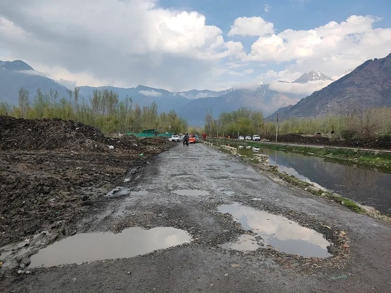
Rough road in Srinagar

JRAFFIC in Srinagar is reaching prodigious proportions, with uncontrollable vehicle crossings from outside and outlying areas worsening the congestion scenario on the roads, a study by Journal of Emerging Technologies and Innovative Research (JETIR) reveals.

Transport is spreading its hydra-headed tentacles, research suggests, prompting commoners and pundits to blame the government for its failure to tackle the disorder.

“The volume of traffic on the roads of the city has doubled beyond its capacity”, indicates the survey of JETIR.

“The capacity of the 1.3 kilometer road between the radio station and Kohli Brothers in Regal Chowk is 1,200 vehicles, but more than 2,421 vehicles pass on the road leading to traffic jams.”

Similarly, the report notes, the capacity of the 0.7 kilometer road between Batamaloo and Bemina is 1,200 vehicles – “however, more than 3,146 vehicles pass on the road leading to traffic jams”.

In a recent interview with Kashmir ObserverSSP Traffic Srinagar, Muzaffar Ahmad Shah said the city’s traffic management is a coordinated effort involving the proactive role of the Department of Roads and Buildings (R&B;) among others.

Apart from the traffic problem, the R&B; also faces questions from the public regarding the rutted roads in Srinagar during the summer.

In conversation with Kashmir ObserverChief Engineer, R&B;, Rafiq Ahmad Rafiq talks about the plight of roads and traffic in the capital of Kashmir.

Chief R&B; Engineer Rafiq A Rafiq. KO photo by Auqib Javeed

Let’s start with the obvious: why hasn’t R&B; fixed the bad roads in Srinagar yet?

Well, not all roads are bad in the city, but yes, some patches need fixing. In fact, soaring oil prices have delayed development activity. We’ve been in the bidding process since March, but the contractors weren’t comfortable with the pricing. We have therefore revised the rates and the problem has been solved.

It was the first time in Kashmir’s history that rates were revised in two years, which would usually take a decade. Thus, the bridges having finally been cleared, we launched a call for tenders for blacktopping in several areas of the city.

But Kashmir has little time for tarmacked roads. Work in most places has not yet started. When are you going to do it then? In winter ?

As I said, we started the bidding process in March, but there were no bidders due to rate issues. With revised rates, work has now begun.

Let me assure you that the macadamization of the roads only started during the summer season for the past two years and we finished it on time.

So, how many kilometers will be traveled in Kashmir this year?

First, let me tell you that R&B; is not the only department responsible for road maintenance in Srinagar.

Srinagar Municipal Corporation (SMC) is in charge of 1394 kilometers out of a total of 1758 kilometers of road section in Srinagar. They were supposed to do macadamization in the city last year, but due to some problems they couldn’t do it. Only 407 kilometers of road fall under R&B.; And the rest, including workarounds, is up to the Beacon agency.

We usually macadamize 2000 kilometers every year, but this year, through various projects, we plan to macadamize more than 1600 kilometres.

But people have this complaint of not removing the crust from the road before the macadamization which makes the roads elevated. Why is this so?

Yes I agree. But we are still evolving and we don’t have such technologies to remove the crust in place and recycle it. But this technology will also be with us one day.

But the city’s potholes have been there for a few years. Poor roads in Natipora, Shalteng, Bemina, Qamarwari and other areas lead to massive traffic jams.

There is no dispute about this observation, but when we went blacktopping in Natipora last year, the locals forbade us to do so. They wanted a concrete road, which was not possible for us. We cannot modify a proposal in a very short time. Thus, the funds for this project have expired.

And yes, regarding the Shalteng section, you can apply to Border Roads Organization (BRO) – the designated agency for this.

So how many level dividers are built in the city?

Currently, two at-grade separators are under construction on the Bemina Highway. And the third, in Sanat Nagar, is under construction.

And what about Qamarwari Chowk?

Well, once the Noorbagh bridge is realigned, the Qamarwari chowk will be redesigned with a wide and hassle-free road.

Moreover, the volume of vehicles has increased considerably over the past decades, but the roads remain the same. Plans to expand the city’s roads?

You see, there has to be a balanced process. The transport system must evolve. Until you have an efficient public transport system, you cannot keep pace with the number of vehicles. But yes, building roads in an already built place is not so easy, it has a huge cost.

Are you saying that Srinagar lacks proper town planning?

Yes, there is a need for holistic urban planning. Everything that happened in the past was theoretical in nature. Urban planning is a subject that deals with pockets. It takes pouches as surgical units.

Moreover, there is no progress in the 4-lane boulevard road project even after 11 years. Why is this so?

In fact, the Lakes and Waterways Development Authority (LAWDA) is the lead agency for the road. They had to carry out an environmental impact study (EIS). Once they finalize it, they will.

  • Syed Burhan contributed to this interview

Follow this link to join our WhatsApp group: Join now

Be part of quality journalism

Quality journalism takes a lot of time, money and hard work to produce and despite all the difficulties, we still do it. Our reporters and editors work overtime in Kashmir and beyond to cover what matters to you, tell great stories and expose injustices that can change lives. Today, more people are reading Kashmir Observer than ever before, but only a handful are paying as advertising revenue plummets.

ACT NOW

CLICK FOR DETAILS


Auqib Javeed

Auqib Javeed is special correspondent with Kashmir Observer and tweets @AuqibJaveed

lessons from urban planning in COVID

Blogs are a double-edged sword. These online essays can be written by anyone with access to a computer and the Internet. Authors could be knowledgeable experts with valuable information to share, or official government agencies. Some bloggers are outstanding academic authors who have published their work in accessible databases, such as Scopus, Web of Science, and Google Scholar. Others may be misinformed people who simply share a biased opinion.

Although readers can comment on a blog, the material does not have the status of Peer-reviewed academic research. Quality and reliability checks are not built into blogging like they are in academic journals. Previous to research discussed the role of blogging communities as reference sources in scientific manuscripts. The University of Cambridge warned its researchers not to trust them.

But some blogs remain attractive as sources of information and ideas for researchers because they often deal with new situations that have not yet been addressed in the traditional academic literature.

The emergence of COVID was a perfect example of a new and rapidly changing situation like this. Vast amounts of information were becoming available online – some of it in blogs that were trusted and useful to the public and scholars, some of it not.

Researchers and students need to know how to balance their data sources.

Little is known about how to identify reliable blog content in our field of study, urban planning. We decided to explore thisstarting by looking at what types of blogs were already being cited by academics, and what Criteria that they used to guide their choice of blogs.

We found that blogs cited in academic publications were mostly published by governmental and non-governmental organizations. We analyzed how these blogs influenced public dialogue on COVID and demonstrated that they were grounded in unique insights that had not yet been peer-reviewed.

We’ve also offered three tips that scholars can use to cite blogs in their research.

Citing blogs on COVID-19

Many urban planning and design scholars and researchers have turned to blogging during the coronavirus outbreak for information. We conducted a scoping study in 2020, analyzing 31 samples from four types of blog sources cited in 10 published publications in seven journals. We reviewed social science journals published in 2020 and searched for blogs that have been used as references in such articles on COVID-19.

We found that in 2020, academics and researchers in urban planning and design used blogs produced by four types of publishers: government agencies, non-governmental organizations, private groups and individuals.

Additionally, we found that academics and researchers cite blogs for three reasons:

  • collect quantitative data from statistical analyzes

  • highlight qualitative knowledge related to social solutions such as social distancing and confinement

  • face the challenges of pandemics through the principles of urban planning.

Blog Citation Criteria

This analysis was part of a larger study on the use of blogs by academics. Based on this work, we have three tips for finding blogs that publish scientific findings on vital topics like COVID-19 and can be cited in scientific articles.

  1. It is possible for academics and researchers in urban planning and design to cite blogs in their scholarly work. This is done by selecting posts that provide relevant analysis, findings and conclusions made by government agencies and non-governmental organizations.

  2. For blogs written by private individuals or groups such as Brooking and
    CityLabit is crucial to keep track of bloggers in scientific databases, such as the Web of Science, Scopus Where Google Scholar. Several metrics can help understand where bloggers stand, including number of citations, h-indexand normalized citation impact.

  3. Citation of blogs can be based on the number of views or reviews, which can indicate the possibility of open debate about the post. However, it’s important to remember that while blog views may seem important, they’re not necessarily a reliable metric for citing blogs. Blog views reflect the importance of the topic rather than the reliability of the information provided in the blog.

By following these tips, academics and researchers can use blogs as trusted sources of information. They may be cited in scientific publications on emerging issues such as COVID-19 in its early stages. These tips can guide scholars and researchers when addressing topics that are still in research or not covered by scientific studies.

How better data can help improve urban planning and reduce inequalities | TheCityFix

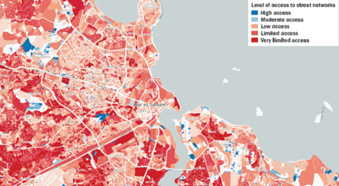
The map shows limited access to road networks in much of Dar es Salaam. Source: Mansueto Institute for Urban Innovation, Map of millions of neighborhoods

High-quality local data can provide valuable information for urban planning and lead to better policies on mobility, climate adaptation, gender equity, and more. But only if the inputs are good and there is enough capacity to parse it effectively.

New technologies like Map of millions of neighborhoods, a tool designed to detect gaps in services at the neighborhood level, helps to improve the quality, granularity and availability of data for urban planning. They are particularly useful in informal settlements. Using algorithms applied to data from the open source GIS database, OpenStreetMapthe Millions of Neighborhoods map identifies communities down to the block level with limited access to road networks, a variable that the University of Chicago’s Mansueto Institute for Urban Innovation says is an effective indicator of access to other basic urban services.

In areas where buildings have limited access to streets, the lack of routes or access points tends to impede the physical delivery or availability of services, including potable water, emergency services and transport. In addition, buildings that are not located on streets lack official addresses, making it more difficult to organize the formal provision of services such as garbage collection.

In this map of Dar es Salaam, red areas represent low-access neighborhoods, areas also more likely to be informal settlements, established with minimal planning and little essential infrastructure. Mapping and understanding the extent of these informal areas is a major challenge in today’s fastest growing cities, as many cities are not keeping up.

Poor access to services can reduce productivity, reduce opportunity, lead to poor health outcomes, inflict severe environmental consequences and lock households into poverty for generations. Conversely, focus on better reach underserved populations can transform cities and deliver benefits to all residents.

In Dar es Salaam, there are far more low-access red areas than blue areas, indicating high informality and a potentially large “urban services gap” between richer and poorer households. Indeed, we know that low-income households in Dar es Salaam typically spend 17% their income on piped water (when the option is even available) and 38% on communal water supply (where it is not), much higher than the United Nations Development Program recommendation 3% of income.

To address informality and service gaps, the government of Dar es Salaam implemented the 20,000 Plot Project, designed to provide planned and serviced land. Unfortunately, less than 17% of the plots were small and affordable, which left out low-income residents and instead generated more informality. In addition, many plots have still not had access to basic urban services, as WRI research explores.

In contrast, programs in Mumbai and Chennai, India, and Windhoek, Namibia, have been successful in fostering more planned and serviced settlements. In India, the introduction of smaller and more varied plot sizes, infrastructure and price standards for different groups has helped create well-planned, well-served, mixed-use and mixed-income neighborhoods. The program linked plot selection with connectivity to employment and transportation and enabled space for social services and commercial businesses run by community residents to thrive. In Namibia, the Windhoek City Government, in cooperation with the Shack Dwellers Federation of Namibia, has succeeded in reducing the cost of formal housing by changing building codes, reducing minimum plot sizes and lowering housing standards. ‘infrastructure.

Even in cities where data collection is still under development, tools like the Million Neighborhood Map can help identify informality and poor access to services to inform better urban planning that benefits all residents. . Other similar initiatives leveraging the kind of open, granular spatial data available on OpenStreetMap are helping cities coping with urban climate risks and responding to humanitarian crises. Ensuring that this localized data on service access gaps is used as input into decision-making at all levels is crucial to ensuring more equitable outcomes for the most vulnerable urban residents.

Sophie Vitello is a Communications and Engagement Assistant at the WRI Ross Center for Sustainable Cities.

Roxbury High School students to study urban planning at UMass Boston

UMass Boston Department of Urban Planning and Community Development and the Pre-College Program, in conjunction with the Boston Planning and Development Agency, Boston Public Schools and Madison Park Technical Vocational High School, are launching a new summer immersion program to introduce young people of color in Boston to the many careers desirable public service available within the fields of planning, design and planning.

The overall goal of this initiative is to increase the percentage of planners of color in Boston from 5.75% to 24% over the next fifteen years.

“As Boston has become one of the most diverse metropolitan areas in the country, people of color are significantly underrepresented in the planning and design professions in our region,” said Ken Redon, professor and director of the Department of Urban Planning and Community Development. “UMass Boston’s recently launched summer planning program at Madison Park Technical Vocational High School in Roxbury reflects our campus’ commitment to addressing this issue.”

Students participating in the 2022 Urban Planning Summer Program will dedicate twenty hours per week throughout July to enhance their understanding of the critical role urban planners play in researching and designing strategies to mitigate the impact of heat overwhelming on local communities.

Using mobile heat sensors and smart phones, these high school students will work with UMass Boston urban planning students and faculty to measure indoor and outdoor air temperatures in schools, agencies service providers, area businesses, housing complexes and parks in their Roxbury communities to locate and map urban heat islands, where extreme temperatures threaten public health. Students will receive a weekly stipend of $200 in recognition of their contribution to this important community research effort.

Students will then collaborate with Roxbury residents and city leaders as well as city planners and climatologists to design viable strategies to address this often overlooked dimension of climate change. The student program will include a boat tour of coastal adaptation sites via the UMass Boston research vessel, M/V Columbia Point, a walking tour of the Rose Kennedy Greenway led by planners from Boston Planning and Development Agency, an engineering design class at the Boston Museum of Science, and an introduction to ongoing legislative debate regarding the Green New Deal at the Edward M. Kennedy Institute for the US Senate.

The program will conclude with a presentation of the students’ “Keep Roxbury Cool Plan” to city leaders, city planners and elected officials in the area on Thursday, July 28 at 7 p.m. in the Harborview Room at the center of the UMass campus.

Students who complete this program will have the opportunity to enroll, tuition-free, in two UMass Boston urban planning courses in the upcoming academic year. At the end of these courses, they will be invited to carry out a paid internship of twelve weeks within a large public and/or private urban planning agency during the summer of 2023.

This urban planning summer program is the latest effort of UMass Boston’s Office of Pre-College Programs to expand higher education opportunities for underserved communities. Some of the programs this office manages to achieve this goal include Upward Bound, Talent Search, and Project REACH. The program is open to all sophomores and juniors attending Boston public schools.

Students interested in participating should contact Professor Ken Reardon at [email protected] or 607-275-7402.

Urban planning incorporating more green space could improve children’s health behaviors

Urban areas with more green space, higher density of buildings and facilities, lower population density, and no main road have been associated with better health behaviors of children.

Research by the Institute for Global Health in Barcelona (ISGlobal), supported by the “la Caixa” Foundation, identified the link after studying the physical activity undertaken by children.

The study showed that children living near more natural spaces are more physically active, spend less time doing sedentary activities, sleep more hours, and are more likely to walk or walk to school. by bike.

Previous studies have focused only on the effect of the urban environment on adults and have not explored all factors, while this new study explored the effects on 1,581 children aged 6 to 11 from six European countries.

A large proportion, 63.6%, did not meet World Health Organization recommendations for at least 60 minutes of physical activity per day, with 58.6% of children spending more than two hours per day watching television or playing video games.

“Our findings have implications for urban planning policies,” said Martine Vrijheid, head of ISGlobal’s Childhood and Environment program and final author of the study. “Public health interventions tend to focus on influencing individual behaviors rather than addressing the broader systemic determinants that drive these behaviors and worsen health inequities.

“Our evidence reinforces the need to prioritize urban design to improve health-promoting behaviors in children and prevent health problems in adults.”

The researchers identified 32 characteristics of urban environments, such as traffic density and green and blue spaces, and estimated children’s exposure to these elements near their homes and schools.

They also gathered information about the children’s health habits, including the time they spend in moderate to vigorous activity, physical activity outside of school hours, active commuting and sedentary activities, such as the sleep.

According to the results, active travel increased and time spent in sedentary activities decreased in places where children were more exposed to green spaces.

Proximity to a major road was also associated with shorter sleep duration, with people living nearby sleeping about 5 minutes less each night than those who did not.

The findings suggest that the amount of green space and vegetation on streets needs to be increased, according to the study authors.

Vrijheid added: “We need further research including other urban indicators that may be relevant to the behavior of children and adolescents, such as pedestrian areas and sports facilities (e.g. table tennis tables , volleyball courts, etc.), and which examines more countries and less-studied areas to better assess how changes in the urban environment affect people’s lifestyles.

In related newsgreen spaces in England and Wales are worth £25.6 billion every year, according to research funded by the Department for Environment, Food and Rural Affairs.

Photo by Kelly Sikkema